Bentiu geodata
Bentiu (Northern Liech) is a seat of a first-order administrative division; located in South Sudan in Africa/Juba (GMT+2) time zone. With population of 7,653 people, there are 16 cities with bigger population in this country. Compared to other cities in South Sudan, 87.9% of cities are located further ↓South; 60.6% of cities are located further →East and 93.9% of cities have higher elevation than Bentiu. Note1


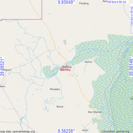
Bentiu GPS coordinates[2]
9° 15' 25.992" North, 29° 47' 53.988" East
| Map corner | latitude | longitude |
|---|---|---|
| Upper-left | 9.95049°, | 29.09521° |
| Center: | 9.25722°, | 29.79833° |
| Lower-right: | 8.56258°, | 30.50146° |
| Map W x H: | 154.3×154.3 km | = 95.9×95.9mi |
| max Lat: | 11.7431° ⇑12.1% North |
| Bentiu: | 9.25722° |
| min Lat: | ⇓87.9% South 3.86512° |
| min Long | Bentiu | max Long |
| 25.67833° | 29.79833° | 33.92621° |
| W 39.4%⇐ | ⇒60.6% E |
Elevation
Elevation of Bentiu is 395 m = 1296 ft, and this is 93.9 m = 308 ft below average elevation for this country.
| Max E: |
836 m = 2743 ft | 93.9% |
| Avg. | 488.9 m = 1604 ft | |
| Bentiu | 395 m = 1296 ft | |
Min E: |
392 m = 1286 ft | 6.1% |
See also: South Sudan elevation on elevation.city.
Geographical zone
Bentiu is located in North Torrid zone (between Equator and Tropic of Cancer). Distance of Equator is 1029.3 km =639.6 mi to South.| Distance of | km | miles | from Bentiu |
|---|---|---|---|
| North Pole | 8977.8 | 5578.5 | to North |
| Arctic Circle | 6371.9 | 3959.3 | to North |
| Tropic Cancer | 1576.6 | 979.7 | to North |
| Equator | 1029.3 | 639.6 | to South |


Nearby cities:
15 places around Bentiu: (largest is in red/bold)
• Aweil
269.9 km =167.7 mi,  258°
258°
• Ayod
217.4 km =135.1 mi,  125°
125°
• Cueibet
255.4 km =158.7 mi,  193°
193°
• Gogrial
203.2 km =126.3 mi,  246°
246°
• Kodok
262.9 km =163.4 mi,  74°
74°
• Kuacjok
226.2 km =140.6 mi,  242°
242°
• Leer
112.6 km =70 mi,  160°
160°
• Malakal
206.6 km =128.4 mi,  81°
81°
• Mayen Abun
160 km =99.4 mi,  265°
265°
• Pariang
75.9 km =47.2 mi,  15°
15°
• Rumbek
272.9 km =169.6 mi,  182°
182°
• Tonj
252.7 km =157 mi,  209°
209°
• Waat
285.1 km =177.2 mi,  114°
114°
• Wau
263.6 km =163.8 mi,  228°
228°
• Winejok
246 km =152.9 mi, 263°
Sources, notices
• [Note1] Compared only with cities in South Sudan existing in our database
• [Src1] Map data: © OpenStreetMap contributors (CC-BY-SA)
• [Src2] Other city data from geonames.org with taken over terms of usage.
• [Src3] Geographical zone / Annual Mean Temperature by Robert A. Rohde @ Wikipedia
