Maiwut geodata
Maiwut is a seat of a first-order administrative division; located in South Sudan in Africa/Juba (GMT+2) time zone. In our database, there are 19 cities with bigger population. Compared to other cities in South Sudan, 72.7% of cities are located further ↓South; 100% of cities are located further ←West and 57.6% of cities have lower elevation than Maiwut. Note1


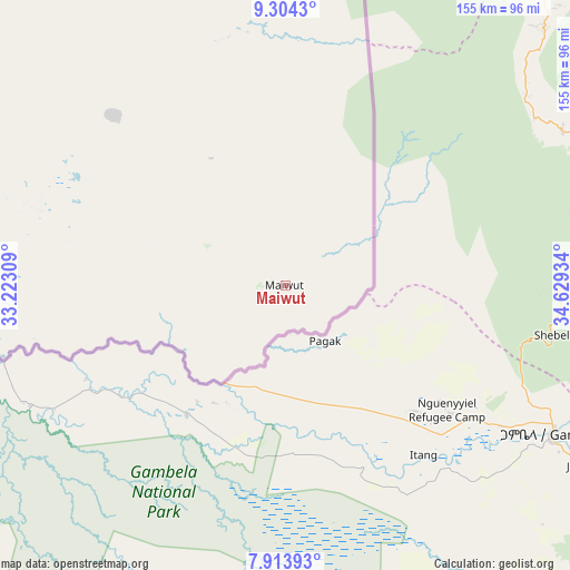
Maiwut GPS coordinates[2]
8° 36' 35.1" North, 33° 55' 34.356" East
| Map corner | latitude | longitude |
|---|---|---|
| Upper-left | 9.3043°, | 33.22309° |
| Center: | 8.60975°, | 33.92621° |
| Lower-right: | 7.91393°, | 34.62934° |
| Map W x H: | 154.6×154.6 km | = 96.1×96.1mi |
| max Lat: | 11.7431° ⇑27.3% North |
| Maiwut: | 8.60975° |
| min Lat: | ⇓72.7% South 3.86512° |
| min Long | Maiwut | max Long |
| 25.67833° | 33.92621° | 33.92621° |
| W 100%⇐ | ⇒0% E |
Elevation
Elevation of Maiwut is 437 m = 1434 ft, and this is 51.9 m = 170 ft below average elevation for this country.
| Max E: |
836 m = 2743 ft | 42.4% |
| Avg. | 488.9 m = 1604 ft | |
| Maiwut | 437 m = 1434 ft | |
Min E: |
392 m = 1286 ft | 57.6% |
See also: South Sudan elevation on elevation.city.
Geographical zone
Maiwut is located in North Torrid zone (between Equator and Tropic of Cancer). Distance of Equator is 957.3 km =594.8 mi to South.| Distance of | km | miles | from Maiwut |
|---|---|---|---|
| North Pole | 9049.7 | 5623.2 | to North |
| Arctic Circle | 6443.9 | 4004.1 | to North |
| Tropic Cancer | 1648.6 | 1024.4 | to North |
| Equator | 957.3 | 594.8 | to South |


Nearby cities:
13 places around Maiwut: (largest is in red/bold)
• Akobo
136.3 km =84.7 mi,  228°
228°
• Ayod
282.2 km =175.4 mi,  258°
258°
• Bor
373.4 km =232 mi,  224°
224°
• Kapoeta
428.3 km =266.1 mi,  184°
184°
• Kodok
244.9 km =152.2 mi,  305°
305°
• Leer
417.7 km =259.5 mi,  265°
265°
• Malakal
269.1 km =167.2 mi,  292°
292°
• Nasir
95 km =59 mi, 270°
• Pibor
219.6 km =136.5 mi,  203°
203°
• Renk
369.4 km =229.5 mi,  340°
340°
• Terekeka
426.1 km =264.8 mi,  214°
214°
• Waat
200.9 km =124.8 mi, 256°
• Yirol
441.7 km =274.5 mi,  238°
238°
Sources, notices
• [Note1] Compared only with cities in South Sudan existing in our database
• [Src1] Map data: © OpenStreetMap contributors (CC-BY-SA)
• [Src2] Other city data from geonames.org with taken over terms of usage.
• [Src3] Geographical zone / Annual Mean Temperature by Robert A. Rohde @ Wikipedia
