Akobo geodata
Akobo is a seat of a first-order administrative division; located in South Sudan in Africa/Juba (GMT+2) time zone. In our database, there are 19 cities with bigger population. Compared to other cities in South Sudan, 51.5% of cities are located further ↓South; 87.9% of cities are located further ←West and 69.7% of cities have higher elevation than Akobo. Note1


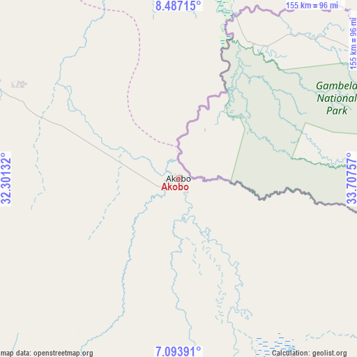
Akobo GPS coordinates[2]
7° 47' 27.996" North, 33° 0' 15.984" East
| Map corner | latitude | longitude |
|---|---|---|
| Upper-left | 8.48715°, | 32.30132° |
| Center: | 7.79111°, | 33.00444° |
| Lower-right: | 7.09391°, | 33.70757° |
| Map W x H: | 154.9×154.9 km | = 96.3×96.3mi |
| max Lat: | 11.7431° ⇑48.5% North |
| Akobo: | 7.79111° |
| min Lat: | ⇓51.5% South 3.86512° |
| min Long | Akobo | max Long |
| 25.67833° | 33.00444° | 33.92621° |
| W 87.9%⇐ | ⇒12.1% E |
Elevation
Elevation of Akobo is 413 m = 1355 ft, and this is 75.9 m = 249 ft below average elevation for this country.
| Max E: |
836 m = 2743 ft | 69.7% |
| Avg. | 488.9 m = 1604 ft | |
| Akobo | 413 m = 1355 ft | |
Min E: |
392 m = 1286 ft | 30.3% |
See also: South Sudan elevation on elevation.city.
Geographical zone
Akobo is located in North Torrid zone (between Equator and Tropic of Cancer). Distance of Equator is 866.3 km =538.3 mi to South.| Distance of | km | miles | from Akobo |
|---|---|---|---|
| North Pole | 9140.8 | 5679.8 | to North |
| Arctic Circle | 6534.9 | 4060.6 | to North |
| Tropic Cancer | 1739.6 | 1080.9 | to North |
| Equator | 866.3 | 538.3 | to South |


Nearby cities:
15 places around Akobo: (largest is in red/bold)
• Ayod
179.5 km =111.5 mi,  281°
281°
• Bor
237.5 km =147.6 mi,  222°
222°
• Juba
362.6 km =225.3 mi,  205°
205°
• Kapoeta
341.9 km =212.4 mi,  169°
169°
• Kodok
253.1 km =157.3 mi,  337°
337°
• Leer
320.4 km =199.1 mi, 280°
• Maiwut
136.3 km =84.7 mi,  48°
48°
• Malakal
243.6 km =151.4 mi,  322°
322°
• Nasir
92 km =57.2 mi,  3°
3°
• Pibor
111.2 km =69.1 mi, 172°
• Rumbek
382.9 km =237.9 mi,  253°
253°
• Terekeka
295.4 km =183.6 mi, 207°
• Torit
378.8 km =235.4 mi,  187°
187°
• Waat
103.3 km =64.2 mi,  294°
294°
• Yirol
308.9 km =191.9 mi,  243°
243°
Sources, notices
• [Note1] Compared only with cities in South Sudan existing in our database
• [Src1] Map data: © OpenStreetMap contributors (CC-BY-SA)
• [Src2] Other city data from geonames.org with taken over terms of usage.
• [Src3] Geographical zone / Annual Mean Temperature by Robert A. Rohde @ Wikipedia
