Malakal geodata
Malakal (Central Upper Nile) is a seat of a first-order administrative division; located in South Sudan in Africa/Juba (GMT+2) time zone. With population of 160,765 people, there are 2 cities with bigger population in this country. Compared to other cities in South Sudan, 90.9% of cities are located further ↓South; 66.7% of cities are located further ←West and 87.9% of cities have higher elevation than Malakal. Note1


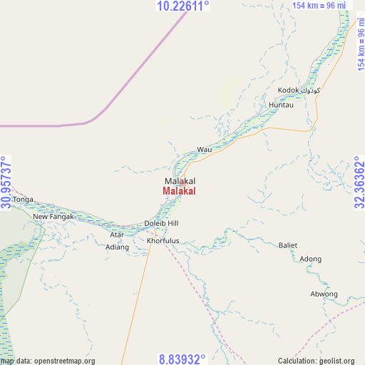
Malakal GPS coordinates[2]
9° 32' 0.312" North, 31° 39' 37.764" East
| Map corner | latitude | longitude |
|---|---|---|
| Upper-left | 10.22611°, | 30.95737° |
| Center: | 9.53342°, | 31.66049° |
| Lower-right: | 8.83932°, | 32.36362° |
| Map W x H: | 154.2×154.2 km | = 95.8×95.8mi |
| max Lat: | 11.7431° ⇑9.1% North |
| Malakal: | 9.53342° |
| min Lat: | ⇓90.9% South 3.86512° |
| min Long | Malakal | max Long |
| 25.67833° | 31.66049° | 33.92621° |
| W 66.7%⇐ | ⇒33.3% E |
Elevation
Elevation of Malakal is 400 m = 1312 ft, and this is 88.9 m = 292 ft below average elevation for this country.
| Max E: |
836 m = 2743 ft | 87.9% |
| Avg. | 488.9 m = 1604 ft | |
| Malakal | 400 m = 1312 ft | |
Min E: |
392 m = 1286 ft | 12.1% |
See also: Malakal elevation on elevation.city.
Geographical zone
Malakal is located in North Torrid zone (between Equator and Tropic of Cancer). Distance of Equator is 1060 km =658.7 mi to South.| Distance of | km | miles | from Malakal |
|---|---|---|---|
| North Pole | 8947 | 5559.4 | to North |
| Arctic Circle | 6341.2 | 3940.2 | to North |
| Tropic Cancer | 1545.9 | 960.6 | to North |
| Equator | 1060 | 658.7 | to South |


Nearby cities:
15 places around Malakal: (largest is in red/bold)
• Akobo
243.6 km =151.4 mi,  142°
142°
• Ayod
159.4 km =99 mi,  189°
189°
• Bentiu
206.6 km =128.4 mi,  261°
261°
• Bor
369.8 km =229.8 mi,  181°
181°
• Kodok
63.1 km =39.2 mi,  51°
51°
• Leer
215.8 km =134.1 mi,  230°
230°
• Maiwut
269.1 km =167.2 mi,  112°
112°
• Mayen Abun
366.3 km =227.6 mi, 263°
• Nasir
184.6 km =114.7 mi,  123°
123°
• Pariang
188.9 km =117.4 mi,  282°
282°
• Pibor
344.4 km =214 mi,  151°
151°
• Renk
275.7 km =171.3 mi,  26°
26°
• Rumbek
373.6 km =232.1 mi,  215°
215°
• Waat
160 km =99.4 mi,  160°
160°
• Yirol
355.3 km =220.8 mi,  201°
201°
Sources, notices
• [Note1] Compared only with cities in South Sudan existing in our database
• [Src1] Map data: © OpenStreetMap contributors (CC-BY-SA)
• [Src2] Other city data from geonames.org with taken over terms of usage.
• [Src3] Geographical zone / Annual Mean Temperature by Robert A. Rohde @ Wikipedia
