San Sebastián geodata
San Sebastián (San Vicente) is a populated place; located in El Salvador in America/El_Salvador (GMT-6) time zone. With population of 7,333 people, there are 55 cities with bigger population in this country. Compared to other cities in El Salvador, 55% of cities are located further ↓South; 60% of cities are located further ←West and 77% of cities have lower elevation than San Sebastián. Note1


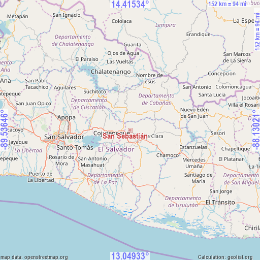
San Sebastián GPS coordinates[2]
13° 43' 59.988" North, 88° 49' 59.988" West
| Map corner | latitude | longitude |
|---|---|---|
| Upper-left | 14.41534°, | -89.53646° |
| Center: | 13.73333°, | -88.83333° |
| Lower-right: | 13.04933°, | -88.13021° |
| Map W x H: | 151.9×151.9 km | = 94.4×94.4mi |
| max Lat: | 14.33333° ⇑45% North |
| San Sebastián: | 13.73333° |
| min Lat: | ⇓55% South 13.19694° |
| min Long | San Sebastián | max Long |
| -90.01583° | -88.83333° | -87.83861° |
| W 60%⇐ | ⇒40% E |
Elevation
Elevation of San Sebastián is 690 m = 2264 ft, and this is 218.1 m = 716 ft above average elevation for this country.
| Max E: |
1255 m = 4117 ft | 23% |
| San Sebastián | 690 m 2264 ft | |
| Avg. | 471.9 m = 1548 ft | |
Min E: |
13 m = 43 ft | 77% |
See also: El Salvador elevation on elevation.city.
Geographical zone
San Sebastián is located in North Torrid zone (between Equator and Tropic of Cancer). Distance of this Northern Tropic circle is 1078.9 km =670.4 mi to North.| Distance of | km | miles | from San Sebastián |
|---|---|---|---|
| North Pole | 8480.1 | 5269.3 | to North |
| Arctic Circle | 5874.2 | 3650.1 | to North |
| Tropic Cancer | 1078.9 | 670.4 | to North |
| Equator | 1527 | 948.8 | to South |


Nearby cities:
15 places around San Sebastián: (largest is in red/bold)
• Apastepeque
9.2 km =5.7 mi,  143°
143°
• Cojutepeque
11 km =6.8 mi,  260°
260°
• Ilopango
30 km =18.6 mi, 263°
• San Martín
10.6 km =6.6 mi,  301°
301°
• San Pedro Masahuat
30.6 km =19 mi,  226°
226°
• San Vicente
11.7 km =7.3 mi,  162°
162°
• Santiago Nonualco
27.2 km =16.9 mi,  207°
207°
• Sensuntepeque
26.2 km =16.3 mi,  55°
55°
• Soyapango
33.2 km =20.6 mi,  265°
265°
• Suchitoto
31 km =19.3 mi,  317°
317°
• Tecoluca
19.6 km =12.2 mi,  288°
288°
• Tenancingo
19.6 km =12.2 mi, 304°
• Tonacatepeque
31.3 km =19.4 mi,  279°
279°
• Victoria
32.4 km =20.1 mi,  41°
41°
• Zacatecoluca
26.2 km =16.3 mi,  187°
187°
Sources, notices
• [Note1] Compared only with cities in El Salvador existing in our database
• [Src1] Map data: © OpenStreetMap contributors (CC-BY-SA)
• [Src2] Other city data from geonames.org with taken over terms of usage.
• [Src3] Geographical zone / Annual Mean Temperature by Robert A. Rohde @ Wikipedia
