Sonsonate geodata
Sonsonate is a seat of a first-order administrative division; located in El Salvador in America/El_Salvador (GMT-6) time zone. With population of 59,468 people, there are 8 cities with bigger population in this country. Compared to other cities in El Salvador, 53% of cities are located further ↓South; 89% of cities are located further →East and 72% of cities have higher elevation than Sonsonate. Note1


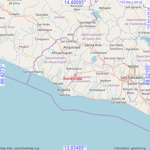
Sonsonate GPS coordinates[2]
13° 43' 8.004" North, 89° 43' 27.012" West
| Map corner | latitude | longitude |
|---|---|---|
| Upper-left | 14.40095°, | -90.4273° |
| Center: | 13.71889°, | -89.72417° |
| Lower-right: | 13.03485°, | -89.02105° |
| Map W x H: | 151.9×151.9 km | = 94.4×94.4mi |
| max Lat: | 14.33333° ⇑47% North |
| Sonsonate: | 13.71889° |
| min Lat: | ⇓53% South 13.19694° |
| min Long | Sonsonate | max Long |
| -90.01583° | -89.72417° | -87.83861° |
| W 11%⇐ | ⇒89% E |
Elevation
Elevation of Sonsonate is 235 m = 771 ft, and this is 236.9 m = 777 ft below average elevation for this country.
| Max E: |
1255 m = 4117 ft | 72% |
| Avg. | 471.9 m = 1548 ft | |
| Sonsonate | 235 m = 771 ft | |
Min E: |
13 m = 43 ft | 28% |
See also: Sonsonate elevation on elevation.city.
Geographical zone
Sonsonate is located in North Torrid zone (between Equator and Tropic of Cancer). Distance of this Northern Tropic circle is 1080.5 km =671.4 mi to North.| Distance of | km | miles | from Sonsonate |
|---|---|---|---|
| North Pole | 8481.7 | 5270.3 | to North |
| Arctic Circle | 5875.8 | 3651.1 | to North |
| Tropic Cancer | 1080.5 | 671.4 | to North |
| Equator | 1525.4 | 947.8 | to South |


Nearby cities:
15 places around Sonsonate: (largest is in red/bold)
• Acajutla
17.9 km =11.1 mi,  218°
218°
• Ahuachapán
26 km =16.2 mi,  329°
329°
• Armenia
24.5 km =15.2 mi,  83°
83°
• Atiquizaya
28.9 km =18 mi,  353°
353°
• Chalchuapa
30.1 km =18.7 mi,  8°
8°
• Concepción de Ataco
21.5 km =13.4 mi,  321°
321°
• El Congo
32.5 km =20.2 mi,  49°
49°
• Guaymango
13.2 km =8.2 mi,  285°
285°
• Izalco
6.2 km =3.9 mi,  62°
62°
• Juayúa
13.8 km =8.6 mi, 350°
• Jujutla
16.2 km =10.1 mi,  297°
297°
• Nahuizalco
6.7 km =4.2 mi, 348°
• San Antonio del Monte
1.6 km =1 mi,  259°
259°
• Sonzacate
2 km =1.2 mi,  30°
30°
• Tacuba
30.1 km =18.7 mi,  312°
312°
Sources, notices
• [Note1] Compared only with cities in El Salvador existing in our database
• [Src1] Map data: © OpenStreetMap contributors (CC-BY-SA)
• [Src2] Other city data from geonames.org with taken over terms of usage.
• [Src3] Geographical zone / Annual Mean Temperature by Robert A. Rohde @ Wikipedia
