San Antonio del Monte geodata
San Antonio del Monte (Sonsonate) is a populated place; located in El Salvador in America/El_Salvador (GMT-6) time zone. With population of 9,135 people, there are 48 cities with bigger population in this country. Compared to other cities in El Salvador, 50% of cities are located further ↓South; 91% of cities are located further →East and 77% of cities have higher elevation than San Antonio del Monte. Note1


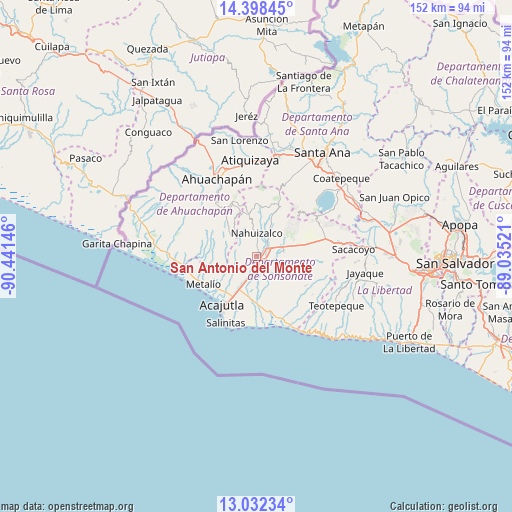
San Antonio del Monte GPS coordinates[2]
13° 42' 59.004" North, 89° 44' 17.988" West
| Map corner | latitude | longitude |
|---|---|---|
| Upper-left | 14.39845°, | -90.44146° |
| Center: | 13.71639°, | -89.73833° |
| Lower-right: | 13.03234°, | -89.03521° |
| Map W x H: | 151.9×151.9 km | = 94.4×94.4mi |
| max Lat: | 14.33333° ⇑50% North |
| San Antonio del Monte: | 13.71639° |
| min Lat: | ⇓50% South 13.19694° |
| min Long | San Antonio del | max Long |
| -90.01583° | -89.73833° | -87.83861° |
| W 9%⇐ | ⇒91% E |
Elevation
Elevation of San Antonio del Monte is 224 m = 735 ft, and this is 247.9 m = 813 ft below average elevation for this country.
| Max E: |
1255 m = 4117 ft | 77% |
| Avg. | 471.9 m = 1548 ft | |
| San Antonio del Monte | 224 m = 735 ft | |
Min E: |
13 m = 43 ft | 23% |
See also: El Salvador elevation on elevation.city.
Geographical zone
San Antonio del Monte is located in North Torrid zone (between Equator and Tropic of Cancer). Distance of this Northern Tropic circle is 1080.8 km =671.6 mi to North.| Distance of | km | miles | from San Antonio del Monte |
|---|---|---|---|
| North Pole | 8481.9 | 5270.4 | to North |
| Arctic Circle | 5876.1 | 3651.2 | to North |
| Tropic Cancer | 1080.8 | 671.6 | to North |
| Equator | 1525.1 | 947.7 | to South |


Nearby cities:
15 places around San Antonio del Monte: (largest is in red/bold)
• Acajutla
16.8 km =10.4 mi,  215°
215°
• Ahuachapán
25.5 km =15.8 mi,  333°
333°
• Armenia
26 km =16.2 mi,  83°
83°
• Atiquizaya
29 km =18 mi,  356°
356°
• Chalchuapa
30.7 km =19.1 mi,  11°
11°
• Concepción de Ataco
20.8 km =12.9 mi, 325°
• Guaymango
11.8 km =7.3 mi,  288°
288°
• Izalco
7.7 km =4.8 mi,  65°
65°
• Juayúa
13.9 km =8.6 mi, 356°
• Jujutla
15 km =9.3 mi,  301°
301°
• Nahuizalco
6.8 km =4.2 mi,  1°
1°
• San Francisco Menéndez
33.1 km =20.6 mi, 295°
• Sonsonate
1.6 km =1 mi, 79°
• Sonzacate
3.2 km =2 mi,  52°
52°
• Tacuba
29.1 km =18.1 mi,  314°
314°
Sources, notices
• [Note1] Compared only with cities in El Salvador existing in our database
• [Src1] Map data: © OpenStreetMap contributors (CC-BY-SA)
• [Src2] Other city data from geonames.org with taken over terms of usage.
• [Src3] Geographical zone / Annual Mean Temperature by Robert A. Rohde @ Wikipedia
