Salqīn geodata
Salqīn (Idlib) is a seat of a third-order administrative division; located in Syria in Asia/Damascus (GMT+3) time zone. With population of 31,608 people, there are 45 cities with bigger population in this country. Compared to other cities in Syria, 80.9% of cities are located further ↓South; 59% of cities are located further →East and 67.1% of cities have higher elevation than Salqīn. Note1


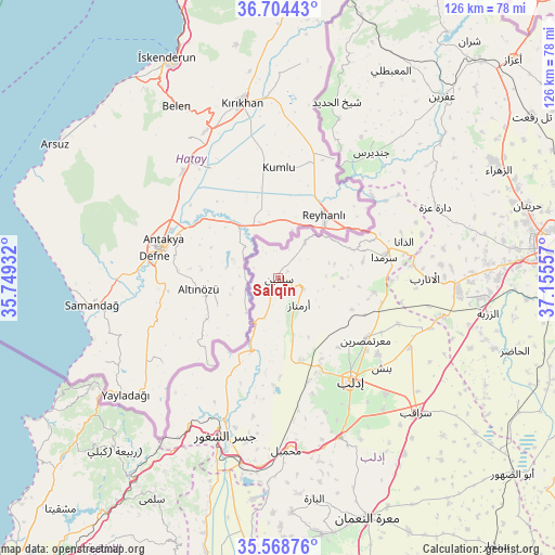
Salqīn GPS coordinates[2]
36° 8' 19.14" North, 36° 27' 8.784" East
| Map corner | latitude | longitude |
|---|---|---|
| Upper-left | 36.70443°, | 35.74932° |
| Center: | 36.13865°, | 36.45244° |
| Lower-right: | 35.56876°, | 37.15557° |
| Map W x H: | 126.3×126.3 km | = 78.5×78.5mi |
| max Lat: | 37.17701° ⇑19.1% North |
| Salqīn: | 36.13865° |
| min Lat: | ⇓80.9% South 32.39332° |
| min Long | Salqīn | max Long |
| 35.75572° | 36.45244° | 42.14006° |
| W 41%⇐ | ⇒59% E |
Elevation
Elevation of Salqīn is 370 m = 1214 ft, and this is 159.1 m = 522 ft below average elevation for this country.
| Max E: |
1640 m = 5381 ft | 67.1% |
| Avg. | 529.1 m = 1736 ft | |
| Salqīn | 370 m = 1214 ft | |
Min E: |
4 m = 13 ft | 32.9% |
See also: Syria elevation on elevation.city.
Geographical zone
Salqīn is located in North temperate zone (between Tropic of Cancer and the Arctic Circle). Distance of this Northern Tropic circle is 1412.3 km =877.6 mi to South.| Distance of | km | miles | from Salqīn |
|---|---|---|---|
| North Pole | 5988.8 | 3721.3 | to North |
| Arctic Circle | 3382.9 | 2102 | to North |
| Tropic Cancer | 1412.3 | 877.6 | to South |
| Equator | 4018.2 | 2496.8 | to South |


Nearby cities:
15 places around Salqīn: (largest is in red/bold)
• Ad Dānā
29.7 km =18.5 mi,  73°
73°
• Al Atārib
33.5 km =20.8 mi,  89°
89°
• Al Jānūdīyah
31.7 km =19.7 mi,  207°
207°
• Armanāz
7.6 km =4.7 mi,  143°
143°
• Binnish
31 km =19.3 mi,  130°
130°
• Darkūsh
17.2 km =10.7 mi,  197°
197°
• Idlib
28.3 km =17.6 mi, 144°
• Jindayris
35.5 km =22.1 mi,  36°
36°
• Jisr ash Shughūr
38 km =23.6 mi, 198°
• Kafr Takhārīm
6.1 km =3.8 mi,  113°
113°
• Ma‘arratmişrīn
24.3 km =15.1 mi, 125°
• Qarqania
14.4 km =8.9 mi, 90°
• Sarmīn
35.8 km =22.2 mi, 136°
• Taftanāz
33.8 km =21 mi,  117°
117°
• Ḩārim
10.2 km =6.3 mi, 37°
Sources, notices
• [Note1] Compared only with cities in Syria existing in our database
• [Src1] Map data: © OpenStreetMap contributors (CC-BY-SA)
• [Src2] Other city data from geonames.org with taken over terms of usage.
• [Src3] Geographical zone / Annual Mean Temperature by Robert A. Rohde @ Wikipedia
