Sarmīn geodata
Sarmīn (Idlib) is a seat of a third-order administrative division; located in Syria in Asia/Damascus (GMT+3) time zone. In our database, there are 87 cities with bigger population. Compared to other cities in Syria, 74.9% of cities are located further ↓South; 59.7% of cities are located further ←West and 62.9% of cities have higher elevation than Sarmīn. Note1


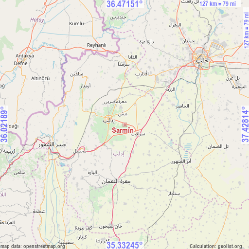
Sarmīn GPS coordinates[2]
35° 54' 14.508" North, 36° 43' 30.036" East
| Map corner | latitude | longitude |
|---|---|---|
| Upper-left | 36.47151°, | 36.02189° |
| Center: | 35.90403°, | 36.72501° |
| Lower-right: | 35.33245°, | 37.42814° |
| Map W x H: | 126.7×126.7 km | = 78.7×78.7mi |
| max Lat: | 37.17701° ⇑25.1% North |
| Sarmīn: | 35.90403° |
| min Lat: | ⇓74.9% South 32.39332° |
| min Long | Sarmīn | max Long |
| 35.75572° | 36.72501° | 42.14006° |
| W 59.7%⇐ | ⇒40.3% E |
Elevation
Elevation of Sarmīn is 390 m = 1280 ft, and this is 139.1 m = 456 ft below average elevation for this country.
| Max E: |
1640 m = 5381 ft | 62.9% |
| Avg. | 529.1 m = 1736 ft | |
| Sarmīn | 390 m = 1280 ft | |
Min E: |
4 m = 13 ft | 37.1% |
See also: Syria elevation on elevation.city.
Geographical zone
Sarmīn is located in North temperate zone (between Tropic of Cancer and the Arctic Circle). Distance of this Northern Tropic circle is 1386.2 km =861.3 mi to South.| Distance of | km | miles | from Sarmīn |
|---|---|---|---|
| North Pole | 6014.9 | 3737.5 | to North |
| Arctic Circle | 3409 | 2118.3 | to North |
| Tropic Cancer | 1386.2 | 861.3 | to South |
| Equator | 3992.2 | 2480.6 | to South |


Nearby cities:
15 places around Sarmīn: (largest is in red/bold)
• Al Atārib
27.6 km =17.1 mi,  18°
18°
• Al Ḩāḑir
30.9 km =19.2 mi,  71°
71°
• Armanāz
28.2 km =17.5 mi,  315°
315°
• Arīḩā
14.5 km =9 mi,  226°
226°
• Az Zarbah
29.3 km =18.2 mi,  51°
51°
• Binnish
5.9 km =3.7 mi,  350°
350°
• Idlib
8.7 km =5.4 mi,  289°
289°
• Iḩsim
25.4 km =15.8 mi,  216°
216°
• Kafr Takhārīm
30.3 km =18.8 mi, 321°
• Ma‘arrat an Nu‘mān
28.8 km =17.9 mi,  188°
188°
• Ma‘arratmişrīn
12.9 km =8 mi,  338°
338°
• Muḩambal
26.2 km =16.3 mi,  240°
240°
• Qarqania
28 km =17.4 mi, 338°
• Sarāqib
8.5 km =5.3 mi,  121°
121°
• Taftanāz
11.8 km =7.3 mi,  27°
27°
Sources, notices
• [Note1] Compared only with cities in Syria existing in our database
• [Src1] Map data: © OpenStreetMap contributors (CC-BY-SA)
• [Src2] Other city data from geonames.org with taken over terms of usage.
• [Src3] Geographical zone / Annual Mean Temperature by Robert A. Rohde @ Wikipedia
