Ma‘arratmişrīn geodata
Ma‘arratmişrīn (Idlib) is a seat of a third-order administrative division; located in Syria in Asia/Damascus (GMT+3) time zone. With population of 32,163 people, there are 43 cities with bigger population in this country. Compared to other cities in Syria, 78.4% of cities are located further ↓South; 55.5% of cities are located further ←West and 73.9% of cities have higher elevation than Ma‘arratmişrīn. Note1


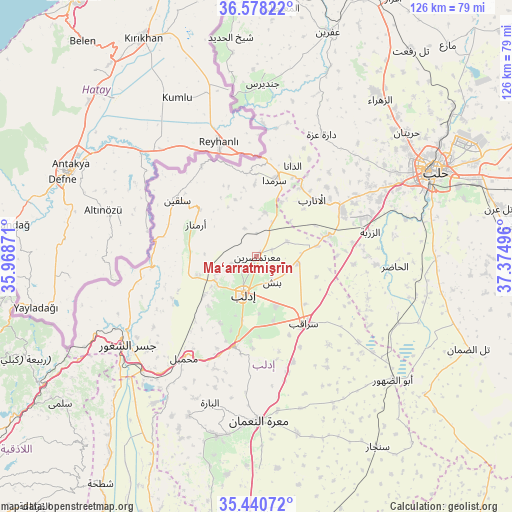
Ma‘arratmişrīn GPS coordinates[2]
36° 0' 41.472" North, 36° 40' 18.588" East
| Map corner | latitude | longitude |
|---|---|---|
| Upper-left | 36.57822°, | 35.96871° |
| Center: | 36.01152°, | 36.67183° |
| Lower-right: | 35.44072°, | 37.37496° |
| Map W x H: | 126.5×126.5 km | = 78.6×78.6mi |
| max Lat: | 37.17701° ⇑21.6% North |
| Ma‘arratmişrīn: | 36.01152° |
| min Lat: | ⇓78.4% South 32.39332° |
| min Long | Ma‘arratmişr | max Long |
| 35.75572° | 36.67183° | 42.14006° |
| W 55.5%⇐ | ⇒44.5% E |
Elevation
Elevation of Ma‘arratmişrīn is 339 m = 1112 ft, and this is 190.1 m = 624 ft below average elevation for this country.
| Max E: |
1640 m = 5381 ft | 73.9% |
| Avg. | 529.1 m = 1736 ft | |
| Ma‘arratmişrīn | 339 m = 1112 ft | |
Min E: |
4 m = 13 ft | 26.1% |
See also: Syria elevation on elevation.city.
Geographical zone
Ma‘arratmişrīn is located in North temperate zone (between Tropic of Cancer and the Arctic Circle). Distance of this Northern Tropic circle is 1398.2 km =868.8 mi to South.| Distance of | km | miles | from Ma‘arratmişrīn |
|---|---|---|---|
| North Pole | 6003 | 3730.1 | to North |
| Arctic Circle | 3397.1 | 2110.9 | to North |
| Tropic Cancer | 1398.2 | 868.8 | to South |
| Equator | 4004.1 | 2488 | to South |


Nearby cities:
15 places around Ma‘arratmişrīn: (largest is in red/bold)
• Ad Dānā
24 km =14.9 mi,  21°
21°
• Al Atārib
19.8 km =12.3 mi,  44°
44°
• Armanāz
17.2 km =10.7 mi,  297°
297°
• Arīḩā
22.7 km =14.1 mi,  194°
194°
• Az Zarbah
28.4 km =17.6 mi,  77°
77°
• Binnish
7.2 km =4.5 mi,  148°
148°
• Darkūsh
25.1 km =15.6 mi,  264°
264°
• Idlib
9.6 km =6 mi,  200°
200°
• Kafr Takhārīm
18.3 km =11.4 mi,  309°
309°
• Qarqania
15.1 km =9.4 mi,  339°
339°
• Salqīn
24.3 km =15.1 mi, 305°
• Sarmīn
12.9 km =8 mi,  158°
158°
• Sarāqib
20.3 km =12.6 mi,  143°
143°
• Taftanāz
10.4 km =6.5 mi,  98°
98°
• Ḩārim
26.1 km =16.2 mi,  328°
328°
Sources, notices
• [Note1] Compared only with cities in Syria existing in our database
• [Src1] Map data: © OpenStreetMap contributors (CC-BY-SA)
• [Src2] Other city data from geonames.org with taken over terms of usage.
• [Src3] Geographical zone / Annual Mean Temperature by Robert A. Rohde @ Wikipedia
