Taftanāz geodata
Taftanāz (Idlib) is a seat of a third-order administrative division; located in Syria in Asia/Damascus (GMT+3) time zone. In our database, there are 87 cities with bigger population. Compared to other cities in Syria, 78.1% of cities are located further ↓South; 65% of cities are located further ←West and 76% of cities have higher elevation than Taftanāz. Note1


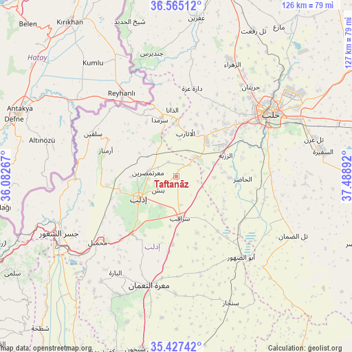
Taftanāz GPS coordinates[2]
35° 59' 53.952" North, 36° 47' 8.844" East
| Map corner | latitude | longitude |
|---|---|---|
| Upper-left | 36.56512°, | 36.08267° |
| Center: | 35.99832°, | 36.78579° |
| Lower-right: | 35.42742°, | 37.48892° |
| Map W x H: | 126.5×126.5 km | = 78.6×78.6mi |
| max Lat: | 37.17701° ⇑21.9% North |
| Taftanāz: | 35.99832° |
| min Lat: | ⇓78.1% South 32.39332° |
| min Long | Taftanāz | max Long |
| 35.75572° | 36.78579° | 42.14006° |
| W 65%⇐ | ⇒35% E |
Elevation
Elevation of Taftanāz is 329 m = 1079 ft, and this is 200.1 m = 656 ft below average elevation for this country.
| Max E: |
1640 m = 5381 ft | 76% |
| Avg. | 529.1 m = 1736 ft | |
| Taftanāz | 329 m = 1079 ft | |
Min E: |
4 m = 13 ft | 24% |
See also: Syria elevation on elevation.city.
Geographical zone
Taftanāz is located in North temperate zone (between Tropic of Cancer and the Arctic Circle). Distance of this Northern Tropic circle is 1396.7 km =867.9 mi to South.| Distance of | km | miles | from Taftanāz |
|---|---|---|---|
| North Pole | 6004.4 | 3731 | to North |
| Arctic Circle | 3398.5 | 2111.7 | to North |
| Tropic Cancer | 1396.7 | 867.9 | to South |
| Equator | 4002.6 | 2487.1 | to South |


Nearby cities:
15 places around Taftanāz: (largest is in red/bold)
• Ad Dānā
23.9 km =14.9 mi,  356°
356°
• Al Atārib
16 km =9.9 mi,  12°
12°
• Al Ḩāḑir
23.9 km =14.9 mi,  92°
92°
• Armanāz
27.1 km =16.8 mi,  290°
290°
• Arīḩā
25.9 km =16.1 mi,  217°
217°
• Az Zarbah
19.1 km =11.9 mi,  66°
66°
• Binnish
8 km =5 mi,  234°
234°
• Dārat ‘Izzah
32.2 km =20 mi, 10°
• Idlib
15.6 km =9.7 mi,  241°
241°
• Kafr Takhārīm
27.7 km =17.2 mi,  298°
298°
• Ma‘arratmişrīn
10.4 km =6.5 mi,  278°
278°
• Qarqania
22 km =13.7 mi,  315°
315°
• Sarmīn
11.8 km =7.3 mi,  207°
207°
• Sarāqib
15 km =9.3 mi,  173°
173°
• Ḩārim
33.6 km =20.9 mi,  314°
314°
Sources, notices
• [Note1] Compared only with cities in Syria existing in our database
• [Src1] Map data: © OpenStreetMap contributors (CC-BY-SA)
• [Src2] Other city data from geonames.org with taken over terms of usage.
• [Src3] Geographical zone / Annual Mean Temperature by Robert A. Rohde @ Wikipedia
