Armanāz geodata
Armanāz (Idlib) is a seat of a third-order administrative division; located in Syria in Asia/Damascus (GMT+3) time zone. In our database, there are 87 cities with bigger population. Compared to other cities in Syria, 79.9% of cities are located further ↓South; 55.5% of cities are located further →East and 74.6% of cities have higher elevation than Armanāz. Note1


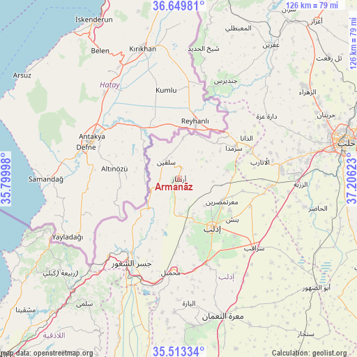
Armanāz GPS coordinates[2]
36° 5' 1.068" North, 36° 30' 11.16" East
| Map corner | latitude | longitude |
|---|---|---|
| Upper-left | 36.64981°, | 35.79998° |
| Center: | 36.08363°, | 36.5031° |
| Lower-right: | 35.51334°, | 37.20623° |
| Map W x H: | 126.4×126.4 km | = 78.5×78.5mi |
| max Lat: | 37.17701° ⇑20.1% North |
| Armanāz: | 36.08363° |
| min Lat: | ⇓79.9% South 32.39332° |
| min Long | Armanāz | max Long |
| 35.75572° | 36.5031° | 42.14006° |
| W 44.5%⇐ | ⇒55.5% E |
Elevation
Elevation of Armanāz is 336 m = 1102 ft, and this is 193.1 m = 634 ft below average elevation for this country.
| Max E: |
1640 m = 5381 ft | 74.6% |
| Avg. | 529.1 m = 1736 ft | |
| Armanāz | 336 m = 1102 ft | |
Min E: |
4 m = 13 ft | 25.4% |
See also: Syria elevation on elevation.city.
Geographical zone
Armanāz is located in North temperate zone (between Tropic of Cancer and the Arctic Circle). Distance of this Northern Tropic circle is 1406.2 km =873.8 mi to South.| Distance of | km | miles | from Armanāz |
|---|---|---|---|
| North Pole | 5994.9 | 3725.1 | to North |
| Arctic Circle | 3389.1 | 2105.9 | to North |
| Tropic Cancer | 1406.2 | 873.8 | to South |
| Equator | 4012.1 | 2493 | to South |


Nearby cities:
15 places around Armanāz: (largest is in red/bold)
• Ad Dānā
27.9 km =17.3 mi,  59°
59°
• Al Atārib
29.6 km =18.4 mi,  77°
77°
• Al Jānūdīyah
29.2 km =18.1 mi,  220°
220°
• Arīḩā
31.5 km =19.6 mi,  162°
162°
• Binnish
23.6 km =14.7 mi,  126°
126°
• Darkūsh
14.2 km =8.8 mi, 223°
• Idlib
20.7 km =12.9 mi,  145°
145°
• Kafr Takhārīm
3.8 km =2.4 mi,  16°
16°
• Ma‘arratmişrīn
17.2 km =10.7 mi,  117°
117°
• Muḩambal
33.1 km =20.6 mi,  184°
184°
• Qarqania
11.6 km =7.2 mi, 58°
• Salqīn
7.6 km =4.7 mi,  323°
323°
• Sarmīn
28.2 km =17.5 mi,  135°
135°
• Taftanāz
27.1 km =16.8 mi,  110°
110°
• Ḩārim
14.3 km =8.9 mi,  6°
6°
Sources, notices
• [Note1] Compared only with cities in Syria existing in our database
• [Src1] Map data: © OpenStreetMap contributors (CC-BY-SA)
• [Src2] Other city data from geonames.org with taken over terms of usage.
• [Src3] Geographical zone / Annual Mean Temperature by Robert A. Rohde @ Wikipedia
