As Sab‘ Biyār geodata
As Sab‘ Biyār (Rif-dimashq) is a seat of a third-order administrative division; located in Syria in Asia/Damascus (GMT+3) time zone. In our database, there are 87 cities with bigger population. Compared to other cities in Syria, 76.7% of cities are located further ↑North; 80.6% of cities are located further ←West and 85.9% of cities have lower elevation than As Sab‘ Biyār. Note1


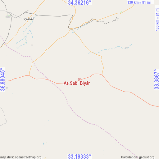
As Sab‘ Biyār GPS coordinates[2]
33° 46' 47.064" North, 37° 41' 0.852" East
| Map corner | latitude | longitude |
|---|---|---|
| Upper-left | 34.36216°, | 36.98045° |
| Center: | 33.77974°, | 37.68357° |
| Lower-right: | 33.19333°, | 38.3867° |
| Map W x H: | 130×130 km | = 80.8×80.8mi |
| max Lat: | 37.17701° ⇑76.7% North |
| As Sab‘ Biyār: | 33.77974° |
| min Lat: | ⇓23.3% South 32.39332° |
| min Long | As Sab‘ Biyā | max Long |
| 35.75572° | 37.68357° | 42.14006° |
| W 80.6%⇐ | ⇒19.4% E |
Elevation
Elevation of As Sab‘ Biyār is 823 m = 2700 ft, and this is 293.9 m = 964 ft above average elevation for this country.
| Max E: |
1640 m = 5381 ft | 14.1% |
| As Sab‘ Biyār | 823 m 2700 ft | |
| Avg. | 529.1 m = 1736 ft | |
Min E: |
4 m = 13 ft | 85.9% |
See also: Syria elevation on elevation.city.
Geographical zone
As Sab‘ Biyār is located in North temperate zone (between Tropic of Cancer and the Arctic Circle). Distance of this Northern Tropic circle is 1150 km =714.6 mi to South.| Distance of | km | miles | from As Sab‘ Biyār |
|---|---|---|---|
| North Pole | 6251.1 | 3884.3 | to North |
| Arctic Circle | 3645.2 | 2265 | to North |
| Tropic Cancer | 1150 | 714.6 | to South |
| Equator | 3756 | 2333.9 | to South |


Nearby cities:
15 places around As Sab‘ Biyār: (largest is in red/bold)
• Al Furqlus
107 km =66.5 mi,  329°
329°
• Al Qaryatayn
64.6 km =40.1 mi,  320°
320°
• Al Quţayfah
100.2 km =62.3 mi,  267°
267°
• An Nabk
92.2 km =57.3 mi,  287°
287°
• Ar Ruḩaybah
90.6 km =56.3 mi, 267°
• Aḑ Ḑumayr
92.8 km =57.7 mi,  260°
260°
• Dayr ‘Aţīyah
91.5 km =56.9 mi, 292°
• Jayrūd
87.4 km =54.3 mi, 271°
• Mahīn
77.2 km =48 mi,  311°
311°
• Ma‘lūlā
105.4 km =65.5 mi, 273°
• Nāḩiyat as Sab‘ Biyār
40.7 km =25.3 mi,  132°
132°
• Qārah
96.3 km =59.8 mi,  295°
295°
• Tadmur
103.1 km =64.1 mi,  32°
32°
• Yabrūd
97.1 km =60.3 mi,  282°
282°
• Şadad
91.6 km =56.9 mi, 310°
Sources, notices
• [Note1] Compared only with cities in Syria existing in our database
• [Src1] Map data: © OpenStreetMap contributors (CC-BY-SA)
• [Src2] Other city data from geonames.org with taken over terms of usage.
• [Src3] Geographical zone / Annual Mean Temperature by Robert A. Rohde @ Wikipedia
