Qārah geodata
Qārah (Rif-dimashq) is a populated place; located in Syria in Asia/Damascus (GMT+3) time zone. With population of 20,656 people, there are 71 cities with bigger population in this country. Compared to other cities in Syria, 73.9% of cities are located further ↑North; 61.8% of cities are located further ←West and 96.8% of cities have lower elevation than Qārah. Note1


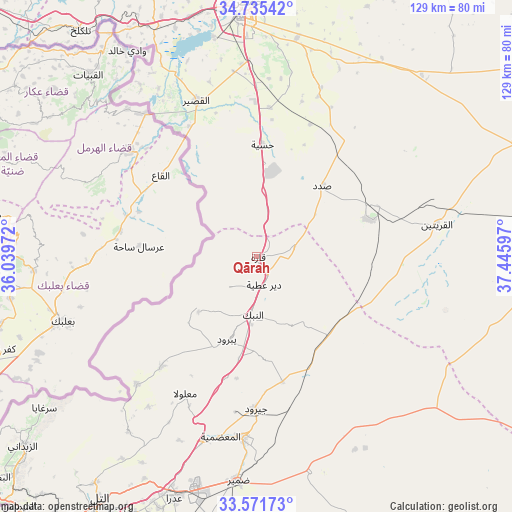
Qārah GPS coordinates[2]
34° 9' 20.088" North, 36° 44' 34.224" East
| Map corner | latitude | longitude |
|---|---|---|
| Upper-left | 34.73542°, | 36.03972° |
| Center: | 34.15558°, | 36.74284° |
| Lower-right: | 33.57173°, | 37.44597° |
| Map W x H: | 129.4×129.4 km | = 80.4×80.4mi |
| max Lat: | 37.17701° ⇑73.9% North |
| Qārah: | 34.15558° |
| min Lat: | ⇓26.1% South 32.39332° |
| min Long | Qārah | max Long |
| 35.75572° | 36.74284° | 42.14006° |
| W 61.8%⇐ | ⇒38.2% E |
Elevation
Elevation of Qārah is 1287 m = 4222 ft, and this is 757.9 m = 2487 ft above average elevation for this country.
| Max E: |
1640 m = 5381 ft | 3.2% |
| Qārah | 1287 m 4222 ft | |
| Avg. | 529.1 m = 1736 ft | |
Min E: |
4 m = 13 ft | 96.8% |
See also: Syria elevation on elevation.city.
Geographical zone
Qārah is located in North temperate zone (between Tropic of Cancer and the Arctic Circle). Distance of this Northern Tropic circle is 1191.8 km =740.5 mi to South.| Distance of | km | miles | from Qārah |
|---|---|---|---|
| North Pole | 6209.3 | 3858.3 | to North |
| Arctic Circle | 3603.4 | 2239 | to North |
| Tropic Cancer | 1191.8 | 740.5 | to South |
| Equator | 3797.7 | 2359.8 | to South |


Nearby cities:
15 places around Qārah: (largest is in red/bold)
• Al Qaryatayn
46.5 km =28.9 mi,  79°
79°
• Al Quşayr
41.9 km =26 mi,  339°
339°
• Al Quţayfah
48.2 km =30 mi,  195°
195°
• An Nabk
14.7 km =9.1 mi,  185°
185°
• Ar Riqāmā
45.6 km =28.3 mi,  20°
20°
• Ar Ruḩaybah
45.9 km =28.5 mi,  184°
184°
• Dayr ‘Aţīyah
7.1 km =4.4 mi,  160°
160°
• Hisya
28.5 km =17.7 mi,  2°
2°
• Jayrūd
38.8 km =24.1 mi, 180°
• Mahīn
30.6 km =19 mi,  71°
71°
• Ma‘lūlā
39 km =24.2 mi,  207°
207°
• Rankūs
55.1 km =34.2 mi,  216°
216°
• Yabrūd
22.2 km =13.8 mi, 200°
• Şadad
24.2 km =15 mi,  43°
43°
• ‘Assāl al Ward
44.3 km =27.5 mi, 223°
Sources, notices
• [Note1] Compared only with cities in Syria existing in our database
• [Src1] Map data: © OpenStreetMap contributors (CC-BY-SA)
• [Src2] Other city data from geonames.org with taken over terms of usage.
• [Src3] Geographical zone / Annual Mean Temperature by Robert A. Rohde @ Wikipedia
