Rankūs geodata
Rankūs (Rif-dimashq) is a seat of a third-order administrative division; located in Syria in Asia/Damascus (GMT+3) time zone. In our database, there are 87 cities with bigger population. Compared to other cities in Syria, 77% of cities are located further ↑North; 63.3% of cities are located further →East and 99.6% of cities have lower elevation than Rankūs. Note1


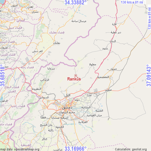
Rankūs GPS coordinates[2]
33° 45' 22.428" North, 36° 23' 17.88" East
| Map corner | latitude | longitude |
|---|---|---|
| Upper-left | 34.33882°, | 35.68518° |
| Center: | 33.75623°, | 36.3883° |
| Lower-right: | 33.16966°, | 37.09143° |
| Map W x H: | 130×130 km | = 80.8×80.8mi |
| max Lat: | 37.17701° ⇑77% North |
| Rankūs: | 33.75623° |
| min Lat: | ⇓23% South 32.39332° |
| min Long | Rankūs | max Long |
| 35.75572° | 36.3883° | 42.14006° |
| W 36.7%⇐ | ⇒63.3% E |
Elevation
Elevation of Rankūs is 1570 m = 5151 ft, and this is 1040.9 m = 3415 ft above average elevation for this country.
| Max E: |
1640 m = 5381 ft | 0.40000000000001% |
| Rankūs | 1570 m 5151 ft | |
| Avg. | 529.1 m = 1736 ft | |
Min E: |
4 m = 13 ft | 99.6% |
See also: Syria elevation on elevation.city.
Geographical zone
Rankūs is located in North temperate zone (between Tropic of Cancer and the Arctic Circle). Distance of this Northern Tropic circle is 1147.4 km =713 mi to South.| Distance of | km | miles | from Rankūs |
|---|---|---|---|
| North Pole | 6253.7 | 3885.9 | to North |
| Arctic Circle | 3647.8 | 2266.6 | to North |
| Tropic Cancer | 1147.4 | 713 | to South |
| Equator | 3753.3 | 2332.2 | to South |


Nearby cities:
15 places around Rankūs: (largest is in red/bold)
• Al Quţayfah
19.7 km =12.2 mi,  95°
95°
• An Nashābīyah
28.8 km =17.9 mi,  161°
161°
• At Tall
17.7 km =11 mi,  203°
203°
• Az Zabadānī
26.8 km =16.7 mi,  262°
262°
• Douma
20.6 km =12.8 mi,  176°
176°
• Kafr Baţnā
27.2 km =16.9 mi, 183°
• Ma‘lūlā
17.6 km =10.9 mi,  55°
55°
• Medaya
27.3 km =17 mi,  254°
254°
• Qadsayyā
28.1 km =17.5 mi,  214°
214°
• Sirghāyā
22.1 km =13.7 mi,  285°
285°
• Şaydnāyā
7 km =4.3 mi,  192°
192°
• Ḩarastā
22.1 km =13.7 mi, 185°
• ‘Assāl al Ward
12.3 km =7.6 mi,  11°
11°
• ‘Ayn al Fījah
24.6 km =15.3 mi,  230°
230°
• ‘Irbīn
24.4 km =15.2 mi, 184°
Sources, notices
• [Note1] Compared only with cities in Syria existing in our database
• [Src1] Map data: © OpenStreetMap contributors (CC-BY-SA)
• [Src2] Other city data from geonames.org with taken over terms of usage.
• [Src3] Geographical zone / Annual Mean Temperature by Robert A. Rohde @ Wikipedia
