Al Quşayr geodata
Al Quşayr (Homs) is a seat of a second-order administrative division; located in Syria in Asia/Damascus (GMT+3) time zone. With population of 41,062 people, there are 32 cities with bigger population in this country. Compared to other cities in Syria, 71.7% of cities are located further ↑North; 50.2% of cities are located further →East and 60.8% of cities have lower elevation than Al Quşayr. Note1


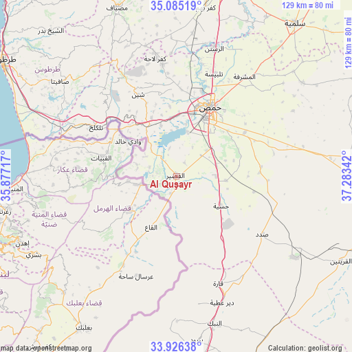
Al Quşayr GPS coordinates[2]
34° 30' 28.08" North, 36° 34' 49.044" East
| Map corner | latitude | longitude |
|---|---|---|
| Upper-left | 35.08519°, | 35.87717° |
| Center: | 34.5078°, | 36.58029° |
| Lower-right: | 33.92638°, | 37.28342° |
| Map W x H: | 128.8×128.8 km | = 80×80mi |
| max Lat: | 37.17701° ⇑71.7% North |
| Al Quşayr: | 34.5078° |
| min Lat: | ⇓28.3% South 32.39332° |
| min Long | Al Quşayr | max Long |
| 35.75572° | 36.58029° | 42.14006° |
| W 49.8%⇐ | ⇒50.2% E |
Elevation
Elevation of Al Quşayr is 541 m = 1775 ft, and this is 11.9 m = 39 ft above average elevation for this country.
| Max E: |
1640 m = 5381 ft | 39.2% |
| Al Quşayr | 541 m 1775 ft | |
| Avg. | 529.1 m = 1736 ft | |
Min E: |
4 m = 13 ft | 60.8% |
See also: Al Quşayr elevation on elevation.city.
Geographical zone
Al Quşayr is located in North temperate zone (between Tropic of Cancer and the Arctic Circle). Distance of this Northern Tropic circle is 1231 km =764.9 mi to South.| Distance of | km | miles | from Al Quşayr |
|---|---|---|---|
| North Pole | 6170.2 | 3834 | to North |
| Arctic Circle | 3564.3 | 2214.8 | to North |
| Tropic Cancer | 1231 | 764.9 | to South |
| Equator | 3836.9 | 2384.1 | to South |


Nearby cities:
15 places around Al Quşayr: (largest is in red/bold)
• Al Ghanţū
36.5 km =22.7 mi,  16°
16°
• Al Qabw
39 km =24.2 mi,  342°
342°
• Al Ḩawāsh
36.7 km =22.8 mi,  319°
319°
• An Nāşirah
41.2 km =25.6 mi, 319°
• Ar Riqāmā
31.2 km =19.4 mi,  83°
83°
• Hisya
19.5 km =12.1 mi,  123°
123°
• Homs
27.6 km =17.1 mi,  28°
28°
• Khirbat Tīn Nūr
21.6 km =13.4 mi,  354°
354°
• Qārah
41.9 km =26 mi,  159°
159°
• Shīn
33.3 km =20.7 mi,  334°
334°
• Tallbīsah
39.5 km =24.5 mi, 20°
• Talldaww
41.3 km =25.7 mi, 352°
• Tallkalakh
34.3 km =21.3 mi,  301°
301°
• Şadad
38.4 km =23.9 mi, 124°
• Ḩadīdah
24.9 km =15.5 mi, 317°
Sources, notices
• [Note1] Compared only with cities in Syria existing in our database
• [Src1] Map data: © OpenStreetMap contributors (CC-BY-SA)
• [Src2] Other city data from geonames.org with taken over terms of usage.
• [Src3] Geographical zone / Annual Mean Temperature by Robert A. Rohde @ Wikipedia
