At Tall geodata
At Tall (Rif-dimashq) is a seat of a second-order administrative division; located in Syria in Asia/Damascus (GMT+3) time zone. With population of 55,561 people, there are 22 cities with bigger population in this country. Compared to other cities in Syria, 79.9% of cities are located further ↑North; 68.9% of cities are located further →East and 92.2% of cities have lower elevation than At Tall. Note1


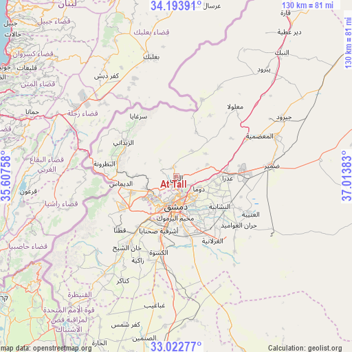
At Tall GPS coordinates[2]
33° 36' 37.188" North, 36° 18' 38.52" East
| Map corner | latitude | longitude |
|---|---|---|
| Upper-left | 34.19391°, | 35.60758° |
| Center: | 33.61033°, | 36.3107° |
| Lower-right: | 33.02277°, | 37.01383° |
| Map W x H: | 130.2×130.2 km | = 80.9×80.9mi |
| max Lat: | 37.17701° ⇑79.9% North |
| At Tall: | 33.61033° |
| min Lat: | ⇓20.1% South 32.39332° |
| min Long | At Tall | max Long |
| 35.75572° | 36.3107° | 42.14006° |
| W 31.1%⇐ | ⇒68.9% E |
Elevation
Elevation of At Tall is 1003 m = 3291 ft, and this is 473.9 m = 1555 ft above average elevation for this country.
| Max E: |
1640 m = 5381 ft | 7.8% |
| At Tall | 1003 m 3291 ft | |
| Avg. | 529.1 m = 1736 ft | |
Min E: |
4 m = 13 ft | 92.2% |
See also: At Tall elevation on elevation.city.
Geographical zone
At Tall is located in North temperate zone (between Tropic of Cancer and the Arctic Circle). Distance of this Northern Tropic circle is 1131.2 km =702.9 mi to South.| Distance of | km | miles | from At Tall |
|---|---|---|---|
| North Pole | 6269.9 | 3895.9 | to North |
| Arctic Circle | 3664.1 | 2276.8 | to North |
| Tropic Cancer | 1131.2 | 702.9 | to South |
| Equator | 3737.1 | 2322.1 | to South |


Nearby cities:
15 places around At Tall: (largest is in red/bold)
• Al Mulayḩah
15.2 km =9.4 mi,  156°
156°
• Al Ḩajar al Aswad
17 km =10.6 mi,  182°
182°
• Babīlā
15.6 km =9.7 mi,  173°
173°
• Damascus
11.3 km =7 mi,  189°
189°
• Dayr al ‘Aşāfīr
19 km =11.8 mi,  147°
147°
• Douma
9.5 km =5.9 mi,  116°
116°
• Dārayyā
18.4 km =11.4 mi,  203°
203°
• Jaramānā
14.2 km =8.8 mi, 166°
• Kafr Baţnā
12.4 km =7.7 mi, 152°
• Qadsayyā
11.2 km =7 mi,  231°
231°
• Rankūs
17.7 km =11 mi,  23°
23°
• Şaydnāyā
10.9 km =6.8 mi,  30°
30°
• Ḩarastā
7.6 km =4.7 mi,  138°
138°
• ‘Ayn al Fījah
11.9 km =7.4 mi,  272°
272°
• ‘Irbīn
9.6 km =6 mi, 147°
Sources, notices
• [Note1] Compared only with cities in Syria existing in our database
• [Src1] Map data: © OpenStreetMap contributors (CC-BY-SA)
• [Src2] Other city data from geonames.org with taken over terms of usage.
• [Src3] Geographical zone / Annual Mean Temperature by Robert A. Rohde @ Wikipedia
