Douma geodata
Douma (Rif-dimashq) is a seat of a second-order administrative division; located in Syria in Asia/Damascus (GMT+3) time zone. With population of 111,864 people, there are 9 cities with bigger population in this country. Compared to other cities in Syria, 80.6% of cities are located further ↑North; 61.1% of cities are located further →East and 73.1% of cities have lower elevation than Douma. Note1


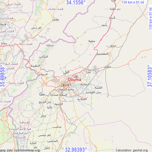
Douma GPS coordinates[2]
33° 34' 18.3" North, 36° 24' 9.72" East
| Map corner | latitude | longitude |
|---|---|---|
| Upper-left | 34.1556°, | 35.69958° |
| Center: | 33.57175°, | 36.4027° |
| Lower-right: | 32.98393°, | 37.10583° |
| Map W x H: | 130.3×130.3 km | = 81×81mi |
| max Lat: | 37.17701° ⇑80.6% North |
| Douma: | 33.57175° |
| min Lat: | ⇓19.4% South 32.39332° |
| min Long | Douma | max Long |
| 35.75572° | 36.4027° | 42.14006° |
| W 38.9%⇐ | ⇒61.1% E |
Elevation
Elevation of Douma is 660 m = 2165 ft, and this is 130.9 m = 429 ft above average elevation for this country.
| Max E: |
1640 m = 5381 ft | 26.9% |
| Douma | 660 m 2165 ft | |
| Avg. | 529.1 m = 1736 ft | |
Min E: |
4 m = 13 ft | 73.1% |
See also: Douma elevation on elevation.city.
Geographical zone
Douma is located in North temperate zone (between Tropic of Cancer and the Arctic Circle). Distance of this Northern Tropic circle is 1126.9 km =700.2 mi to South.| Distance of | km | miles | from Douma |
|---|---|---|---|
| North Pole | 6274.2 | 3898.6 | to North |
| Arctic Circle | 3668.3 | 2279.4 | to North |
| Tropic Cancer | 1126.9 | 700.2 | to South |
| Equator | 3732.8 | 2319.5 | to South |


Nearby cities:
15 places around Douma: (largest is in red/bold)
• Al Ghizlānīyah
20.1 km =12.5 mi,  166°
166°
• Al Mulayḩah
9.9 km =6.2 mi,  194°
194°
• Al Ḩajar al Aswad
15.6 km =9.7 mi,  215°
215°
• An Nashābīyah
10.3 km =6.4 mi,  131°
131°
• At Tall
9.5 km =5.9 mi,  296°
296°
• Babīlā
13 km =8.1 mi,  210°
210°
• Damascus
12.4 km =7.7 mi,  236°
236°
• Dayr al ‘Aşāfīr
11.9 km =7.4 mi, 172°
• Jaramānā
10.9 km =6.8 mi, 208°
• Kafr Baţnā
7.2 km =4.5 mi,  202°
202°
• Qadsayyā
17.5 km =10.9 mi,  261°
261°
• Şaydnāyā
14 km =8.7 mi,  348°
348°
• Ḩarastā
3.8 km =2.4 mi,  247°
247°
• Ḩarrān al ‘Awāmīd
20 km =12.4 mi, 133°
• ‘Irbīn
5.1 km =3.2 mi, 221°
Sources, notices
• [Note1] Compared only with cities in Syria existing in our database
• [Src1] Map data: © OpenStreetMap contributors (CC-BY-SA)
• [Src2] Other city data from geonames.org with taken over terms of usage.
• [Src3] Geographical zone / Annual Mean Temperature by Robert A. Rohde @ Wikipedia
