Maskanah geodata
Maskanah (Aleppo) is a seat of a third-order administrative division; located in Syria in Asia/Damascus (GMT+3) time zone. In our database, there are 87 cities with bigger population. Compared to other cities in Syria, 76.7% of cities are located further ↓South; 83.7% of cities are located further ←West and 65.4% of cities have higher elevation than Maskanah. Note1


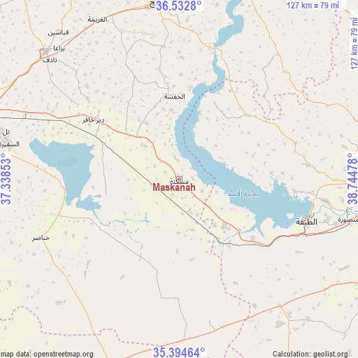
Maskanah GPS coordinates[2]
35° 57' 56.772" North, 38° 2' 29.94" East
| Map corner | latitude | longitude |
|---|---|---|
| Upper-left | 36.5328°, | 37.33853° |
| Center: | 35.96577°, | 38.04165° |
| Lower-right: | 35.39464°, | 38.74478° |
| Map W x H: | 126.6×126.6 km | = 78.7×78.7mi |
| max Lat: | 37.17701° ⇑23.3% North |
| Maskanah: | 35.96577° |
| min Lat: | ⇓76.7% South 32.39332° |
| min Long | Maskanah | max Long |
| 35.75572° | 38.04165° | 42.14006° |
| W 83.7%⇐ | ⇒16.3% E |
Elevation
Elevation of Maskanah is 376 m = 1234 ft, and this is 153.1 m = 502 ft below average elevation for this country.
| Max E: |
1640 m = 5381 ft | 65.4% |
| Avg. | 529.1 m = 1736 ft | |
| Maskanah | 376 m = 1234 ft | |
Min E: |
4 m = 13 ft | 34.6% |
See also: Syria elevation on elevation.city.
Geographical zone
Maskanah is located in North temperate zone (between Tropic of Cancer and the Arctic Circle). Distance of this Northern Tropic circle is 1393.1 km =865.6 mi to South.| Distance of | km | miles | from Maskanah |
|---|---|---|---|
| North Pole | 6008 | 3733.2 | to North |
| Arctic Circle | 3402.2 | 2114 | to North |
| Tropic Cancer | 1393.1 | 865.6 | to South |
| Equator | 3999 | 2484.9 | to South |


Nearby cities:
15 places around Maskanah: (largest is in red/bold)
• Abū Qalqal
53 km =32.9 mi,  7°
7°
• Al Bāb
65.2 km =40.5 mi,  313°
313°
• Al Jarnīyah
27.7 km =17.2 mi,  38°
38°
• Al Khafsah
29.6 km =18.4 mi,  356°
356°
• Al Manşūrah
64.7 km =40.2 mi,  102°
102°
• Al Ḩājib
59.2 km =36.8 mi,  258°
258°
• Al ‘Arīmah
63.3 km =39.3 mi,  332°
332°
• As Safīrah
61.4 km =38.2 mi,  281°
281°
• Ath Thawrah
47.8 km =29.7 mi,  107°
107°
• Dayr Ḩāfir
36.8 km =22.9 mi, 305°
• Khanāşir
53 km =32.9 mi,  247°
247°
• Kuwayris Sharqī
50.5 km =31.4 mi,  296°
296°
• Manbij
63 km =39.1 mi,  352°
352°
• Rasm al Ḩarmal
42.6 km =26.5 mi,  316°
316°
• Tādif
62.5 km =38.8 mi, 312°
Sources, notices
• [Note1] Compared only with cities in Syria existing in our database
• [Src1] Map data: © OpenStreetMap contributors (CC-BY-SA)
• [Src2] Other city data from geonames.org with taken over terms of usage.
• [Src3] Geographical zone / Annual Mean Temperature by Robert A. Rohde @ Wikipedia
