As Safīrah geodata
As Safīrah (Aleppo) is a seat of a second-order administrative division; located in Syria in Asia/Damascus (GMT+3) time zone. With population of 63,708 people, there are 19 cities with bigger population in this country. Compared to other cities in Syria, 79.5% of cities are located further ↓South; 77.4% of cities are located further ←West and 74.2% of cities have higher elevation than As Safīrah. Note1


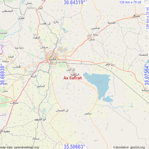
As Safīrah GPS coordinates[2]
36° 4' 37.056" North, 37° 22' 21.036" East
| Map corner | latitude | longitude |
|---|---|---|
| Upper-left | 36.64319°, | 36.66939° |
| Center: | 36.07696°, | 37.37251° |
| Lower-right: | 35.50663°, | 38.07564° |
| Map W x H: | 126.4×126.4 km | = 78.5×78.5mi |
| max Lat: | 37.17701° ⇑20.5% North |
| As Safīrah: | 36.07696° |
| min Lat: | ⇓79.5% South 32.39332° |
| min Long | As Safīrah | max Long |
| 35.75572° | 37.37251° | 42.14006° |
| W 77.4%⇐ | ⇒22.6% E |
Elevation
Elevation of As Safīrah is 337 m = 1106 ft, and this is 192.1 m = 630 ft below average elevation for this country.
| Max E: |
1640 m = 5381 ft | 74.2% |
| Avg. | 529.1 m = 1736 ft | |
| As Safīrah | 337 m = 1106 ft | |
Min E: |
4 m = 13 ft | 25.8% |
See also: As Safīrah elevation on elevation.city.
Geographical zone
As Safīrah is located in North temperate zone (between Tropic of Cancer and the Arctic Circle). Distance of this Northern Tropic circle is 1405.5 km =873.3 mi to South.| Distance of | km | miles | from As Safīrah |
|---|---|---|---|
| North Pole | 5995.7 | 3725.6 | to North |
| Arctic Circle | 3389.8 | 2106.3 | to North |
| Tropic Cancer | 1405.5 | 873.3 | to South |
| Equator | 4011.4 | 2492.6 | to South |


Nearby cities:
15 places around As Safīrah: (largest is in red/bold)
• Abū az̧ Z̧uhūr
47.6 km =29.6 mi,  218°
218°
• Al Bāb
35.1 km =21.8 mi,  21°
21°
• Al Ḩājib
23.8 km =14.8 mi,  174°
174°
• Al Ḩāḑir
30.5 km =19 mi,  251°
251°
• Aleppo
23.5 km =14.6 mi,  306°
306°
• Az Zarbah
35.3 km =21.9 mi,  268°
268°
• Banān
13.1 km =8.1 mi,  208°
208°
• Dayr Ḩāfir
31.4 km =19.5 mi,  73°
73°
• Kafr Şaghīr
26.2 km =16.3 mi,  336°
336°
• Khanāşir
34.8 km =21.6 mi,  160°
160°
• Kuwayris Sharqī
17.9 km =11.1 mi,  56°
56°
• Rasm al Ḩarmal
36.1 km =22.4 mi, 58°
• Tall aḑ Ḑamān
31.8 km =19.8 mi,  199°
199°
• Tādif
33.3 km =20.7 mi,  25°
25°
• Ḩuraytān
34.9 km =21.7 mi, 312°
Sources, notices
• [Note1] Compared only with cities in Syria existing in our database
• [Src1] Map data: © OpenStreetMap contributors (CC-BY-SA)
• [Src2] Other city data from geonames.org with taken over terms of usage.
• [Src3] Geographical zone / Annual Mean Temperature by Robert A. Rohde @ Wikipedia
