Tādif geodata
Tādif (Aleppo) is a seat of a third-order administrative division; located in Syria in Asia/Damascus (GMT+3) time zone. With population of 34,670 people, there are 39 cities with bigger population in this country. Compared to other cities in Syria, 85.9% of cities are located further ↓South; 79.9% of cities are located further ←West and 55.8% of cities have higher elevation than Tādif. Note1


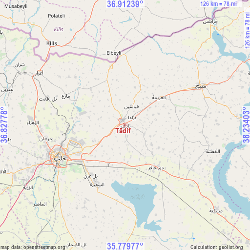
Tādif GPS coordinates[2]
36° 20' 53.304" North, 37° 31' 51.24" East
| Map corner | latitude | longitude |
|---|---|---|
| Upper-left | 36.91239°, | 36.82778° |
| Center: | 36.34814°, | 37.5309° |
| Lower-right: | 35.77977°, | 38.23403° |
| Map W x H: | 125.9×125.9 km | = 78.2×78.2mi |
| max Lat: | 37.17701° ⇑14.1% North |
| Tādif: | 36.34814° |
| min Lat: | ⇓85.9% South 32.39332° |
| min Long | Tādif | max Long |
| 35.75572° | 37.5309° | 42.14006° |
| W 79.9%⇐ | ⇒20.1% E |
Elevation
Elevation of Tādif is 440 m = 1444 ft, and this is 89.1 m = 292 ft below average elevation for this country.
| Max E: |
1640 m = 5381 ft | 55.8% |
| Avg. | 529.1 m = 1736 ft | |
| Tādif | 440 m = 1444 ft | |
Min E: |
4 m = 13 ft | 44.2% |
See also: Syria elevation on elevation.city.
Geographical zone
Tādif is located in North temperate zone (between Tropic of Cancer and the Arctic Circle). Distance of this Northern Tropic circle is 1435.6 km =892 mi to South.| Distance of | km | miles | from Tādif |
|---|---|---|---|
| North Pole | 5965.5 | 3706.8 | to North |
| Arctic Circle | 3359.6 | 2087.6 | to North |
| Tropic Cancer | 1435.6 | 892 | to South |
| Equator | 4041.5 | 2511.3 | to South |


Nearby cities:
15 places around Tādif: (largest is in red/bold)
• Akhtarīn
25.1 km =15.6 mi,  315°
315°
• Al Bāb
2.8 km =1.7 mi,  331°
331°
• Al Ghandūrah
40 km =24.9 mi,  26°
26°
• Al ‘Arīmah
22 km =13.7 mi,  50°
50°
• Aleppo
36.9 km =22.9 mi,  243°
243°
• As Safīrah
33.3 km =20.7 mi,  205°
205°
• Dayr Ḩāfir
26.5 km =16.5 mi,  143°
143°
• Kafr Şaghīr
25.4 km =15.8 mi,  255°
255°
• Kuwayris Sharqī
20.2 km =12.6 mi,  178°
178°
• Māri‘
33.4 km =20.8 mi,  296°
296°
• Rasm al Ḩarmal
20.2 km =12.6 mi,  124°
124°
• Tall Rif‘at
41.4 km =25.7 mi,  289°
289°
• Tchoban Bey
30.2 km =18.8 mi,  345°
345°
• Şūrān
37.4 km =23.2 mi,  310°
310°
• Ḩuraytān
40.5 km =25.2 mi, 260°
Sources, notices
• [Note1] Compared only with cities in Syria existing in our database
• [Src1] Map data: © OpenStreetMap contributors (CC-BY-SA)
• [Src2] Other city data from geonames.org with taken over terms of usage.
• [Src3] Geographical zone / Annual Mean Temperature by Robert A. Rohde @ Wikipedia
