Manbij geodata
Manbij (Aleppo) is a seat of a second-order administrative division; located in Syria in Asia/Damascus (GMT+3) time zone. With population of 99,497 people, there are 10 cities with bigger population in this country. Compared to other cities in Syria, 90.8% of cities are located further ↓South; 82.3% of cities are located further ←West and 50.5% of cities have higher elevation than Manbij. Note1


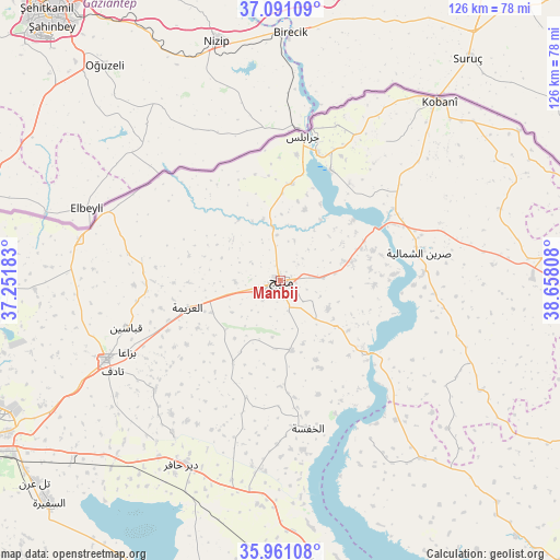
Manbij GPS coordinates[2]
36° 31' 41.34" North, 37° 57' 17.82" East
| Map corner | latitude | longitude |
|---|---|---|
| Upper-left | 37.09109°, | 37.25183° |
| Center: | 36.52815°, | 37.95495° |
| Lower-right: | 35.96108°, | 38.65808° |
| Map W x H: | 125.6×125.6 km | = 78×78mi |
| max Lat: | 37.17701° ⇑9.2% North |
| Manbij: | 36.52815° |
| min Lat: | ⇓90.8% South 32.39332° |
| min Long | Manbij | max Long |
| 35.75572° | 37.95495° | 42.14006° |
| W 82.3%⇐ | ⇒17.7% E |
Elevation
Elevation of Manbij is 468 m = 1535 ft, and this is 61.1 m = 200 ft below average elevation for this country.
| Max E: |
1640 m = 5381 ft | 50.5% |
| Avg. | 529.1 m = 1736 ft | |
| Manbij | 468 m = 1535 ft | |
Min E: |
4 m = 13 ft | 49.5% |
See also: Manbij elevation on elevation.city.
Geographical zone
Manbij is located in North temperate zone (between Tropic of Cancer and the Arctic Circle). Distance of this Northern Tropic circle is 1455.6 km =904.5 mi to South.| Distance of | km | miles | from Manbij |
|---|---|---|---|
| North Pole | 5945.5 | 3694.4 | to North |
| Arctic Circle | 3339.6 | 2075.1 | to North |
| Tropic Cancer | 1455.6 | 904.5 | to South |
| Equator | 4061.5 | 2523.7 | to South |


Nearby cities:
15 places around Manbij: (largest is in red/bold)
• Abū Qalqal
17.8 km =11.1 mi,  124°
124°
• Al Bāb
43 km =26.7 mi,  245°
245°
• Al Ghandūrah
25.3 km =15.7 mi,  308°
308°
• Al Jarnīyah
47.9 km =29.8 mi,  148°
148°
• Al Khafsah
33.6 km =20.9 mi,  169°
169°
• Al ‘Arīmah
21.8 km =13.5 mi, 253°
• Dayr Ḩāfir
46.8 km =29.1 mi,  208°
208°
• Jarābulus
32.6 km =20.3 mi,  8°
8°
• Kuwayris Sharqī
54.8 km =34.1 mi,  222°
222°
• Rasm al Ḩarmal
38.1 km =23.7 mi, 214°
• Shuyūkh Taḩtānī
27 km =16.8 mi,  23°
23°
• Tchoban Bey
46.2 km =28.7 mi,  281°
281°
• Tādif
42.9 km =26.7 mi,  242°
242°
• Şirrīn ash Shamālīyah
31.4 km =19.5 mi,  77°
77°
• ‘Ayn al ‘Arab
53.8 km =33.4 mi,  41°
41°
Sources, notices
• [Note1] Compared only with cities in Syria existing in our database
• [Src1] Map data: © OpenStreetMap contributors (CC-BY-SA)
• [Src2] Other city data from geonames.org with taken over terms of usage.
• [Src3] Geographical zone / Annual Mean Temperature by Robert A. Rohde @ Wikipedia
