Ath Thawrah geodata
Ath Thawrah (Ar-Raqqah) is a seat of a second-order administrative division; located in Syria in Asia/Damascus (GMT+3) time zone. With population of 87,880 people, there are 14 cities with bigger population in this country. Compared to other cities in Syria, 72.8% of cities are located further ↓South; 86.2% of cities are located further ←West and 72.8% of cities have higher elevation than Ath Thawrah. Note1


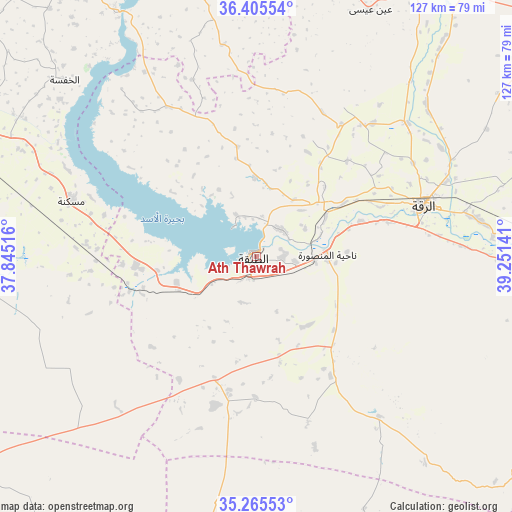
Ath Thawrah GPS coordinates[2]
35° 50' 15.288" North, 38° 32' 53.808" East
| Map corner | latitude | longitude |
|---|---|---|
| Upper-left | 36.40554°, | 37.84516° |
| Center: | 35.83758°, | 38.54828° |
| Lower-right: | 35.26553°, | 39.25141° |
| Map W x H: | 126.8×126.8 km | = 78.8×78.8mi |
| max Lat: | 37.17701° ⇑27.2% North |
| Ath Thawrah: | 35.83758° |
| min Lat: | ⇓72.8% South 32.39332° |
| min Long | Ath Thawrah | max Long |
| 35.75572° | 38.54828° | 42.14006° |
| W 86.2%⇐ | ⇒13.8% E |
Elevation
Elevation of Ath Thawrah is 342 m = 1122 ft, and this is 187.1 m = 614 ft below average elevation for this country.
| Max E: |
1640 m = 5381 ft | 72.8% |
| Avg. | 529.1 m = 1736 ft | |
| Ath Thawrah | 342 m = 1122 ft | |
Min E: |
4 m = 13 ft | 27.2% |
See also: Ath Thawrah elevation on elevation.city.
Geographical zone
Ath Thawrah is located in North temperate zone (between Tropic of Cancer and the Arctic Circle). Distance of this Northern Tropic circle is 1378.8 km =856.7 mi to South.| Distance of | km | miles | from Ath Thawrah |
|---|---|---|---|
| North Pole | 6022.3 | 3742.1 | to North |
| Arctic Circle | 3416.4 | 2122.9 | to North |
| Tropic Cancer | 1378.8 | 856.7 | to South |
| Equator | 3984.8 | 2476 | to South |


Nearby cities:
15 places around Ath Thawrah: (largest is in red/bold)
• Abū Qalqal
77.1 km =47.9 mi,  330°
330°
• Al Jarnīyah
45.7 km =28.4 mi,  321°
321°
• Al Karāmah
65.9 km =40.9 mi,  86°
86°
• Al Khafsah
64.5 km =40.1 mi,  312°
312°
• Al Manşūrah
17.5 km =10.9 mi, 89°
• Ar Raqqah
43.3 km =26.9 mi,  72°
72°
• As Sabkhah
64.5 km =40.1 mi, 92°
• Dayr Ḩāfir
83.5 km =51.9 mi,  295°
295°
• Khanāşir
94.8 km =58.9 mi,  266°
266°
• Manbij
93.4 km =58 mi, 325°
• Maskanah
47.8 km =29.7 mi,  287°
287°
• Ma‘dān
95.1 km =59.1 mi,  95°
95°
• Rasm al Ḩarmal
87.5 km =54.4 mi, 301°
• Şirrīn ash Shamālīyah
86.5 km =53.7 mi,  344°
344°
• ‘Ayn ‘Īsá
67.1 km =41.7 mi,  24°
24°
Sources, notices
• [Note1] Compared only with cities in Syria existing in our database
• [Src1] Map data: © OpenStreetMap contributors (CC-BY-SA)
• [Src2] Other city data from geonames.org with taken over terms of usage.
• [Src3] Geographical zone / Annual Mean Temperature by Robert A. Rohde @ Wikipedia
