Al Khafsah geodata
Al Khafsah (Aleppo) is a seat of a third-order administrative division; located in Syria in Asia/Damascus (GMT+3) time zone. In our database, there are 87 cities with bigger population. Compared to other cities in Syria, 83.7% of cities are located further ↓South; 83.4% of cities are located further ←West and 69.6% of cities have higher elevation than Al Khafsah. Note1


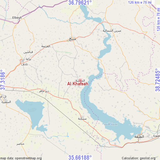
Al Khafsah GPS coordinates[2]
36° 13' 51.96" North, 38° 1' 18.192" East
| Map corner | latitude | longitude |
|---|---|---|
| Upper-left | 36.79621°, | 37.3186° |
| Center: | 36.2311°, | 38.02172° |
| Lower-right: | 35.66188°, | 38.72485° |
| Map W x H: | 126.1×126.1 km | = 78.4×78.4mi |
| max Lat: | 37.17701° ⇑16.3% North |
| Al Khafsah: | 36.2311° |
| min Lat: | ⇓83.7% South 32.39332° |
| min Long | Al Khafsah | max Long |
| 35.75572° | 38.02172° | 42.14006° |
| W 83.4%⇐ | ⇒16.6% E |
Elevation
Elevation of Al Khafsah is 355 m = 1165 ft, and this is 174.1 m = 571 ft below average elevation for this country.
| Max E: |
1640 m = 5381 ft | 69.6% |
| Avg. | 529.1 m = 1736 ft | |
| Al Khafsah | 355 m = 1165 ft | |
Min E: |
4 m = 13 ft | 30.4% |
See also: Syria elevation on elevation.city.
Geographical zone
Al Khafsah is located in North temperate zone (between Tropic of Cancer and the Arctic Circle). Distance of this Northern Tropic circle is 1422.6 km =884 mi to South.| Distance of | km | miles | from Al Khafsah |
|---|---|---|---|
| North Pole | 5978.5 | 3714.9 | to North |
| Arctic Circle | 3372.7 | 2095.7 | to North |
| Tropic Cancer | 1422.6 | 884 | to South |
| Equator | 4028.5 | 2503.2 | to South |


Nearby cities:
15 places around Al Khafsah: (largest is in red/bold)
• Abū Qalqal
24.6 km =15.3 mi,  20°
20°
• Al Bāb
47.9 km =29.8 mi,  288°
288°
• Al Ghandūrah
55.2 km =34.3 mi,  332°
332°
• Al Jarnīyah
20.5 km =12.7 mi,  112°
112°
• Al ‘Arīmah
38 km =23.6 mi,  314°
314°
• As Safīrah
60.8 km =37.8 mi,  253°
253°
• Ath Thawrah
64.5 km =40.1 mi,  132°
132°
• Dayr Ḩāfir
29.4 km =18.3 mi, 253°
• Kuwayris Sharqī
44 km =27.3 mi,  260°
260°
• Manbij
33.6 km =20.9 mi,  349°
349°
• Maskanah
29.6 km =18.4 mi,  176°
176°
• Rasm al Ḩarmal
27.5 km =17.1 mi,  273°
273°
• Shuyūkh Taḩtānī
58 km =36 mi,  4°
4°
• Tādif
45.9 km =28.5 mi, 286°
• Şirrīn ash Shamālīyah
46.8 km =29.1 mi,  31°
31°
Sources, notices
• [Note1] Compared only with cities in Syria existing in our database
• [Src1] Map data: © OpenStreetMap contributors (CC-BY-SA)
• [Src2] Other city data from geonames.org with taken over terms of usage.
• [Src3] Geographical zone / Annual Mean Temperature by Robert A. Rohde @ Wikipedia
