Al Bāb geodata
Al Bāb (Aleppo) is a seat of a second-order administrative division; located in Syria in Asia/Damascus (GMT+3) time zone. With population of 130,745 people, there are 7 cities with bigger population in this country. Compared to other cities in Syria, 86.2% of cities are located further ↓South; 79.5% of cities are located further ←West and 52.7% of cities have higher elevation than Al Bāb. Note1


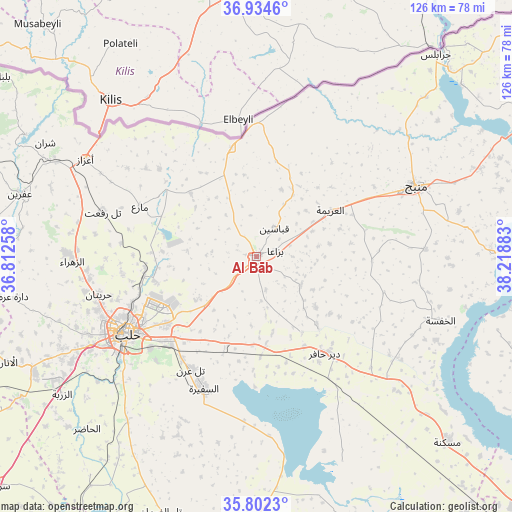
Al Bāb GPS coordinates[2]
36° 22' 13.836" North, 37° 30' 56.52" East
| Map corner | latitude | longitude |
|---|---|---|
| Upper-left | 36.9346°, | 36.81258° |
| Center: | 36.37051°, | 37.5157° |
| Lower-right: | 35.8023°, | 38.21883° |
| Map W x H: | 125.9×125.9 km | = 78.2×78.2mi |
| max Lat: | 37.17701° ⇑13.8% North |
| Al Bāb: | 36.37051° |
| min Lat: | ⇓86.2% South 32.39332° |
| min Long | Al Bāb | max Long |
| 35.75572° | 37.5157° | 42.14006° |
| W 79.5%⇐ | ⇒20.5% E |
Elevation
Elevation of Al Bāb is 460 m = 1509 ft, and this is 69.1 m = 227 ft below average elevation for this country.
| Max E: |
1640 m = 5381 ft | 52.7% |
| Avg. | 529.1 m = 1736 ft | |
| Al Bāb | 460 m = 1509 ft | |
Min E: |
4 m = 13 ft | 47.3% |
See also: Al Bāb elevation on elevation.city.
Geographical zone
Al Bāb is located in North temperate zone (between Tropic of Cancer and the Arctic Circle). Distance of this Northern Tropic circle is 1438.1 km =893.6 mi to South.| Distance of | km | miles | from Al Bāb |
|---|---|---|---|
| North Pole | 5963 | 3705.2 | to North |
| Arctic Circle | 3357.2 | 2086.1 | to North |
| Tropic Cancer | 1438.1 | 893.6 | to South |
| Equator | 4044 | 2512.8 | to South |


Nearby cities:
15 places around Al Bāb: (largest is in red/bold)
• Akhtarīn
22.4 km =13.9 mi,  314°
314°
• Al Ghandūrah
38.5 km =23.9 mi,  30°
30°
• Al ‘Arīmah
21.6 km =13.4 mi,  58°
58°
• Aleppo
36.9 km =22.9 mi,  239°
239°
• As Safīrah
35.1 km =21.8 mi,  201°
201°
• Dayr Ḩāfir
29.3 km =18.2 mi,  144°
144°
• Kafr Şaghīr
24.8 km =15.4 mi,  249°
249°
• Kuwayris Sharqī
22.7 km =14.1 mi,  174°
174°
• Māri‘
31.1 km =19.3 mi,  293°
293°
• Rasm al Ḩarmal
22.7 km =14.1 mi,  127°
127°
• Tall Rif‘at
39.3 km =24.4 mi, 286°
• Tchoban Bey
27.5 km =17.1 mi,  347°
347°
• Tādif
2.8 km =1.7 mi,  151°
151°
• Şūrān
34.7 km =21.6 mi, 308°
• Ḩuraytān
39.6 km =24.6 mi,  256°
256°
Sources, notices
• [Note1] Compared only with cities in Syria existing in our database
• [Src1] Map data: © OpenStreetMap contributors (CC-BY-SA)
• [Src2] Other city data from geonames.org with taken over terms of usage.
• [Src3] Geographical zone / Annual Mean Temperature by Robert A. Rohde @ Wikipedia
