Homs geodata
Homs is a seat of a first-order administrative division; located in Syria in Asia/Damascus (GMT+3) time zone. With population of 775,404 people, there are 2 cities with bigger population in this country. Compared to other cities in Syria, 67.5% of cities are located further ↑North; 59.4% of cities are located further ←West and 57.2% of cities have lower elevation than Homs. Note1


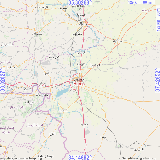
Homs GPS coordinates[2]
34° 43' 36.552" North, 36° 43' 24.204" East
| Map corner | latitude | longitude |
|---|---|---|
| Upper-left | 35.30268°, | 36.02027° |
| Center: | 34.72682°, | 36.72339° |
| Lower-right: | 34.14692°, | 37.42652° |
| Map W x H: | 128.5×128.5 km | = 79.8×79.8mi |
| max Lat: | 37.17701° ⇑67.5% North |
| Homs: | 34.72682° |
| min Lat: | ⇓32.5% South 32.39332° |
| min Long | Homs | max Long |
| 35.75572° | 36.72339° | 42.14006° |
| W 59.4%⇐ | ⇒40.6% E |
Elevation
Elevation of Homs is 513 m = 1683 ft, and this is 16.1 m = 53 ft below average elevation for this country.
| Max E: |
1640 m = 5381 ft | 42.8% |
| Avg. | 529.1 m = 1736 ft | |
| Homs | 513 m = 1683 ft | |
Min E: |
4 m = 13 ft | 57.2% |
See also: Homs elevation on elevation.city.
Geographical zone
Homs is located in North temperate zone (between Tropic of Cancer and the Arctic Circle). Distance of this Northern Tropic circle is 1255.3 km =780 mi to South.| Distance of | km | miles | from Homs |
|---|---|---|---|
| North Pole | 6145.8 | 3818.8 | to North |
| Arctic Circle | 3539.9 | 2199.6 | to North |
| Tropic Cancer | 1255.3 | 780 | to South |
| Equator | 3861.3 | 2399.3 | to South |


Nearby cities:
15 places around Homs: (largest is in red/bold)
• Al Ghanţū
10.9 km =6.8 mi,  346°
346°
• Al Qabw
27.7 km =17.2 mi,  297°
297°
• Al Quşayr
27.6 km =17.1 mi,  208°
208°
• Ar Rastan
22.2 km =13.8 mi,  2°
2°
• Ar Riqāmā
27.5 km =17.1 mi,  139°
139°
• Hisya
35.2 km =21.9 mi,  174°
174°
• Kafr Lāhā
27.9 km =17.3 mi,  311°
311°
• Khirbat Tīn Nūr
15.5 km =9.6 mi,  259°
259°
• Mukharram al Fawqānī
34.6 km =21.5 mi,  73°
73°
• Shīn
28 km =17.4 mi,  281°
281°
• Tallbīsah
12.7 km =7.9 mi, 3°
• Talldaww
24.7 km =15.3 mi, 312°
• Ḩadīdah
30.4 km =18.9 mi, 258°
• Ḩarbinafsah
25.2 km =15.7 mi,  338°
338°
• ‘Ayn an Nasr
22.6 km =14 mi,  55°
55°
Sources, notices
• [Note1] Compared only with cities in Syria existing in our database
• [Src1] Map data: © OpenStreetMap contributors (CC-BY-SA)
• [Src2] Other city data from geonames.org with taken over terms of usage.
• [Src3] Geographical zone / Annual Mean Temperature by Robert A. Rohde @ Wikipedia
