As Sabkhah geodata
As Sabkhah (Ar-Raqqah) is a seat of a third-order administrative division; located in Syria in Asia/Damascus (GMT+3) time zone. In our database, there are 87 cities with bigger population. Compared to other cities in Syria, 71.4% of cities are located further ↓South; 88.7% of cities are located further ←West and 83% of cities have higher elevation than As Sabkhah. Note1


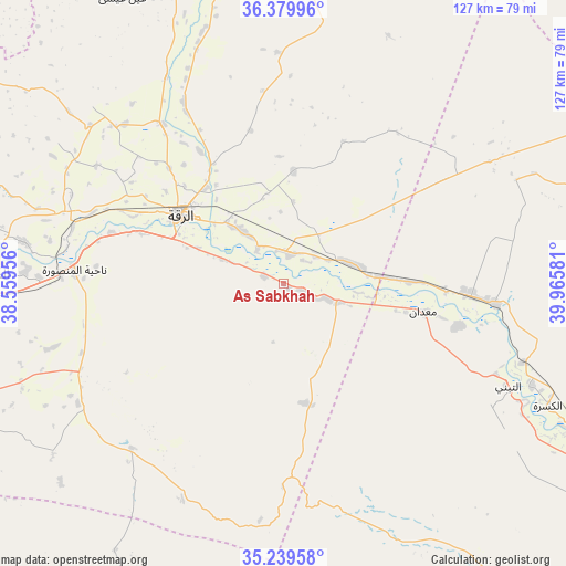
As Sabkhah GPS coordinates[2]
35° 48' 42.552" North, 39° 15' 45.648" East
| Map corner | latitude | longitude |
|---|---|---|
| Upper-left | 36.37996°, | 38.55956° |
| Center: | 35.81182°, | 39.26268° |
| Lower-right: | 35.23958°, | 39.96581° |
| Map W x H: | 126.8×126.8 km | = 78.8×78.8mi |
| max Lat: | 37.17701° ⇑28.6% North |
| As Sabkhah: | 35.81182° |
| min Lat: | ⇓71.4% South 32.39332° |
| min Long | As Sabkhah | max Long |
| 35.75572° | 39.26268° | 42.14006° |
| W 88.7%⇐ | ⇒11.3% E |
Elevation
Elevation of As Sabkhah is 251 m = 823 ft, and this is 278.1 m = 912 ft below average elevation for this country.
| Max E: |
1640 m = 5381 ft | 83% |
| Avg. | 529.1 m = 1736 ft | |
| As Sabkhah | 251 m = 823 ft | |
Min E: |
4 m = 13 ft | 17% |
See also: Syria elevation on elevation.city.
Geographical zone
As Sabkhah is located in North temperate zone (between Tropic of Cancer and the Arctic Circle). Distance of this Northern Tropic circle is 1376 km =855 mi to South.| Distance of | km | miles | from As Sabkhah |
|---|---|---|---|
| North Pole | 6025.2 | 3743.9 | to North |
| Arctic Circle | 3419.3 | 2124.7 | to North |
| Tropic Cancer | 1376 | 855 | to South |
| Equator | 3981.9 | 2474.2 | to South |


Nearby cities:
15 places around As Sabkhah: (largest is in red/bold)
• Al Jarnīyah
100.4 km =62.4 mi,  292°
292°
• Al Karāmah
6.5 km =4 mi,  12°
12°
• Al Kasrah
65.3 km =40.6 mi,  114°
114°
• Al Manşūrah
47 km =29.2 mi,  273°
273°
• Ar Raqqah
27.8 km =17.3 mi,  304°
304°
• As Sukhnah
109 km =67.7 mi,  199°
199°
• At Tibnī
54.9 km =34.1 mi, 113°
• Ath Thawrah
64.5 km =40.1 mi, 272°
• Deir ez-Zor
95.4 km =59.3 mi,  123°
123°
• Khushām
108.9 km =67.7 mi, 121°
• Maskanah
111.3 km =69.2 mi,  278°
278°
• Ma‘dān
30.9 km =19.2 mi,  101°
101°
• Sulūk
88 km =54.7 mi,  352°
352°
• Tall Abyaḑ
102.2 km =63.5 mi,  344°
344°
• ‘Ayn ‘Īsá
73.2 km =45.5 mi,  330°
330°
Sources, notices
• [Note1] Compared only with cities in Syria existing in our database
• [Src1] Map data: © OpenStreetMap contributors (CC-BY-SA)
• [Src2] Other city data from geonames.org with taken over terms of usage.
• [Src3] Geographical zone / Annual Mean Temperature by Robert A. Rohde @ Wikipedia
