Sa Khrai geodata
Sa Khrai (Nong Khai) is a seat of a second-order administrative division; located in Thailand in Asia/Bangkok (GMT+7) time zone. In our database, there are 331 cities with bigger population. Compared to other cities in Thailand, 85.8% of cities are located further ↓South; 76.5% of cities are located further ←West and 71.4% of cities have lower elevation than Sa Khrai. Note1


Sa Khrai GPS coordinates[2]
17° 40' 31.584" North, 102° 45' 2.484" East
| Map corner | latitude | longitude |
|---|---|---|
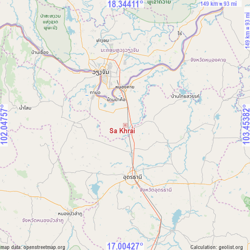
| Upper-left | 18.34411°, | 102.04757° |
| Center: | 17.67544°, | 102.75069° |
| Lower-right: | 17.00427°, | 103.45382° |
| Map W x H: | 149×149 km | = 92.6×92.6mi |
| max Lat: | 20.43353° ⇑14.2% North |
| Sa Khrai: | 17.67544° |
| min Lat: | ⇓85.8% South 5.77434° |
| min Long | Sa Khrai | max Long |
| 97.93288° | 102.75069° | 105.49506° |
| W 76.5%⇐ | ⇒23.5% E |
Elevation
Elevation of Sa Khrai is 173 m = 568 ft, and this is 47.5 m = 156 ft above average elevation for this country.
| Max E: |
1011 m = 3317 ft | 28.6% |
| Sa Khrai | 173 m 568 ft | |
| Avg. | 125.5 m = 412 ft | |
Min E: |
1 m = 3 ft | 71.4% |
See also: Thailand elevation on elevation.city.
Geographical zone
Sa Khrai is located in North Torrid zone (between Equator and Tropic of Cancer). Distance of this Northern Tropic circle is 640.6 km =398.1 mi to North.| Distance of | km | miles | from Sa Khrai |
|---|---|---|---|
| North Pole | 8041.7 | 4996.9 | to North |
| Arctic Circle | 5435.8 | 3377.6 | to North |
| Tropic Cancer | 640.6 | 398.1 | to North |
| Equator | 1965.3 | 1221.2 | to South |


Nearby cities:
15 places around Sa Khrai: (largest is in red/bold)
• Ban Phue
28.8 km =17.9 mi,  272°
272°
• Kut Chap
33.9 km =21.1 mi,  215°
215°
• Nong Han
51.4 km =31.9 mi,  132°
132°
• Nong Khai
22.6 km =14 mi,  357°
357°
• Phen
16.7 km =10.4 mi,  82°
82°
• Phibun Rak
35.3 km =21.9 mi,  112°
112°
• Pho Tak
42.9 km =26.7 mi,  301°
301°
• Phon Phisai
51.6 km =32.1 mi,  41°
41°
• Phonphisai
51.6 km =32.1 mi, 41°
• Sang Khom
39.9 km =24.8 mi,  65°
65°
• Si Chiang Mai
35.7 km =22.2 mi,  330°
330°
• Suwanna Khuha
51.4 km =31.9 mi,  255°
255°
• Suwannakhuha
51.4 km =31.9 mi, 255°
• Tha Bo
26.4 km =16.4 mi,  317°
317°
• Udon Thani
29.1 km =18.1 mi,  172°
172°
Sources, notices
• [Note1] Compared only with cities in Thailand existing in our database
• [Src1] Map data: © OpenStreetMap contributors (CC-BY-SA)
• [Src2] Other city data from geonames.org with taken over terms of usage.
• [Src3] Geographical zone / Annual Mean Temperature by Robert A. Rohde @ Wikipedia
