Nong Khai geodata
Nong Khai is a seat of a first-order administrative division; located in Thailand in Asia/Bangkok (GMT+7) time zone. With population of 63,609 people, there are 37 cities with bigger population in this country. Compared to other cities in Thailand, 87.4% of cities are located further ↓South; 76.3% of cities are located further ←West and 69.5% of cities have lower elevation than Nong Khai. Note1


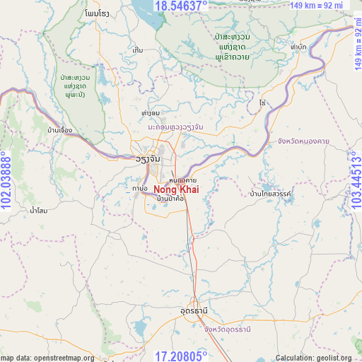
Nong Khai GPS coordinates[2]
17° 52' 42.492" North, 102° 44' 31.2" East
| Map corner | latitude | longitude |
|---|---|---|
| Upper-left | 18.54637°, | 102.03888° |
| Center: | 17.87847°, | 102.742° |
| Lower-right: | 17.20805°, | 103.44513° |
| Map W x H: | 148.8×148.8 km | = 92.5×92.5mi |
| max Lat: | 20.43353° ⇑12.6% North |
| Nong Khai: | 17.87847° |
| min Lat: | ⇓87.4% South 5.77434° |
| min Long | Nong Khai | max Long |
| 97.93288° | 102.742° | 105.49506° |
| W 76.3%⇐ | ⇒23.7% E |
Elevation
Elevation of Nong Khai is 168 m = 551 ft, and this is 42.5 m = 139 ft above average elevation for this country.
| Max E: |
1011 m = 3317 ft | 30.5% |
| Nong Khai | 168 m 551 ft | |
| Avg. | 125.5 m = 412 ft | |
Min E: |
1 m = 3 ft | 69.5% |
See also: Nong Khai elevation on elevation.city.
Geographical zone
Nong Khai is located in North Torrid zone (between Equator and Tropic of Cancer). Distance of this Northern Tropic circle is 618 km =384 mi to North.| Distance of | km | miles | from Nong Khai |
|---|---|---|---|
| North Pole | 8019.2 | 4982.9 | to North |
| Arctic Circle | 5413.3 | 3363.7 | to North |
| Tropic Cancer | 618 | 384 | to North |
| Equator | 1987.9 | 1235.2 | to South |


Nearby cities:
15 places around Nong Khai: (largest is in red/bold)
• Ban Dung
58.3 km =36.2 mi,  110°
110°
• Ban Phue
35 km =21.7 mi,  232°
232°
• Kut Chap
53.7 km =33.4 mi,  200°
200°
• Phen
26.8 km =16.7 mi,  139°
139°
• Phibun Rak
49.3 km =30.6 mi, 137°
• Pho Tak
35.8 km =22.2 mi,  269°
269°
• Phon Charoen
48.1 km =29.9 mi,  69°
69°
• Phon Phisai
38.8 km =24.1 mi, 65°
• Phonphisai
38.8 km =24.1 mi, 65°
• Sa Khrai
22.6 km =14 mi,  177°
177°
• Sang Khom
37.6 km =23.4 mi,  98°
98°
• Sangkhom
53.7 km =33.4 mi,  292°
292°
• Si Chiang Mai
18.6 km =11.6 mi,  297°
297°
• Tha Bo
17.3 km =10.7 mi,  259°
259°
• Udon Thani
51.7 km =32.1 mi,  174°
174°
Sources, notices
• [Note1] Compared only with cities in Thailand existing in our database
• [Src1] Map data: © OpenStreetMap contributors (CC-BY-SA)
• [Src2] Other city data from geonames.org with taken over terms of usage.
• [Src3] Geographical zone / Annual Mean Temperature by Robert A. Rohde @ Wikipedia
