Tha Bo geodata
Tha Bo (Nong Khai) is a seat of a second-order administrative division; located in Thailand in Asia/Bangkok (GMT+7) time zone. With population of 35,292 people, there are 91 cities with bigger population in this country. Compared to other cities in Thailand, 87% of cities are located further ↓South; 74.3% of cities are located further ←West and 74.9% of cities have lower elevation than Tha Bo. Note1


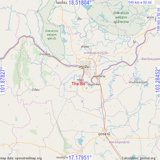
Tha Bo GPS coordinates[2]
17° 51' 0.108" North, 102° 34' 53.004" East
| Map corner | latitude | longitude |
|---|---|---|
| Upper-left | 18.51804°, | 101.87827° |
| Center: | 17.85003°, | 102.58139° |
| Lower-right: | 17.17951°, | 103.28452° |
| Map W x H: | 148.8×148.8 km | = 92.5×92.5mi |
| max Lat: | 20.43353° ⇑13% North |
| Tha Bo: | 17.85003° |
| min Lat: | ⇓87% South 5.77434° |
| min Long | Tha Bo | max Long |
| 97.93288° | 102.58139° | 105.49506° |
| W 74.3%⇐ | ⇒25.7% E |
Elevation
Elevation of Tha Bo is 182 m = 597 ft, and this is 56.5 m = 185 ft above average elevation for this country.
| Max E: |
1011 m = 3317 ft | 25.1% |
| Tha Bo | 182 m 597 ft | |
| Avg. | 125.5 m = 412 ft | |
Min E: |
1 m = 3 ft | 74.9% |
See also: Thailand elevation on elevation.city.
Geographical zone
Tha Bo is located in North Torrid zone (between Equator and Tropic of Cancer). Distance of this Northern Tropic circle is 621.2 km =386 mi to North.| Distance of | km | miles | from Tha Bo |
|---|---|---|---|
| North Pole | 8022.3 | 4984.8 | to North |
| Arctic Circle | 5416.4 | 3365.6 | to North |
| Tropic Cancer | 621.2 | 386 | to North |
| Equator | 1984.7 | 1233.2 | to South |


Nearby cities:
15 places around Tha Bo: (largest is in red/bold)
• Ban Phue
21 km =13 mi,  211°
211°
• Kut Chap
47.2 km =29.3 mi,  181°
181°
• Na Yung
46 km =28.6 mi,  276°
276°
• Nam Som
42.4 km =26.3 mi,  257°
257°
• Nong Khai
17.3 km =10.7 mi,  79°
79°
• Phen
38.5 km =23.9 mi,  116°
116°
• Pho Tak
19 km =11.8 mi, 278°
• Phonphisai
55.7 km =34.6 mi,  70°
70°
• Sa Khrai
26.4 km =16.4 mi,  137°
137°
• Sang Khom
54.2 km =33.7 mi,  92°
92°
• Sangkhom
40.3 km =25 mi,  306°
306°
• Si Chiang Mai
11.8 km =7.3 mi,  2°
2°
• Suwanna Khuha
45.2 km =28.1 mi,  225°
225°
• Suwannakhuha
45.2 km =28.1 mi, 225°
• Udon Thani
52.9 km =32.9 mi,  155°
155°
Sources, notices
• [Note1] Compared only with cities in Thailand existing in our database
• [Src1] Map data: © OpenStreetMap contributors (CC-BY-SA)
• [Src2] Other city data from geonames.org with taken over terms of usage.
• [Src3] Geographical zone / Annual Mean Temperature by Robert A. Rohde @ Wikipedia
