Udon Thani geodata
Udon Thani (Changwat Udon Thani) is a seat of a first-order administrative division; located in Thailand in Asia/Bangkok (GMT+7) time zone. With population of 247,231 people, there are 3 cities with bigger population in this country. Compared to other cities in Thailand, 83.2% of cities are located further ↓South; 76.8% of cities are located further ←West and 72.8% of cities have lower elevation than Udon Thani. Note1


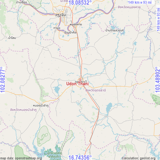
Udon Thani GPS coordinates[2]
17° 24' 56.412" North, 102° 47' 9.204" East
| Map corner | latitude | longitude |
|---|---|---|
| Upper-left | 18.08532°, | 102.08277° |
| Center: | 17.41567°, | 102.78589° |
| Lower-right: | 16.74356°, | 103.48902° |
| Map W x H: | 149.2×149.2 km | = 92.7×92.7mi |
| max Lat: | 20.43353° ⇑16.8% North |
| Udon Thani: | 17.41567° |
| min Lat: | ⇓83.2% South 5.77434° |
| min Long | Udon Thani | max Long |
| 97.93288° | 102.78589° | 105.49506° |
| W 76.8%⇐ | ⇒23.2% E |
Elevation
Elevation of Udon Thani is 177 m = 581 ft, and this is 51.5 m = 169 ft above average elevation for this country.
| Max E: |
1011 m = 3317 ft | 27.2% |
| Udon Thani | 177 m 581 ft | |
| Avg. | 125.5 m = 412 ft | |
Min E: |
1 m = 3 ft | 72.8% |
See also: Udon Thani elevation on elevation.city.
Geographical zone
Udon Thani is located in North Torrid zone (between Equator and Tropic of Cancer). Distance of this Northern Tropic circle is 669.5 km =416 mi to North.| Distance of | km | miles | from Udon Thani |
|---|---|---|---|
| North Pole | 8070.6 | 5014.8 | to North |
| Arctic Circle | 5464.7 | 3395.6 | to North |
| Tropic Cancer | 669.5 | 416 | to North |
| Equator | 1936.4 | 1203.2 | to South |


Nearby cities:
15 places around Udon Thani: (largest is in red/bold)
• Ban Na Muang
30.8 km =19.1 mi,  129°
129°
• Ban Nong Wua So
49.4 km =30.7 mi,  109°
109°
• Ban Phan Don
36.3 km =22.6 mi,  146°
146°
• Ban Phue
44.5 km =27.7 mi,  313°
313°
• Chaiwan
49.4 km =30.7 mi, 105°
• Ku Kaeo
47.5 km =29.5 mi,  124°
124°
• Kumphawapi
41.9 km =26 mi,  144°
144°
• Kut Chap
23.3 km =14.5 mi,  272°
272°
• Nong Bua Lamphu
43.5 km =27 mi,  237°
237°
• Nong Han
34.4 km =21.4 mi,  100°
100°
• Nong Saeng
27.6 km =17.1 mi,  181°
181°
• Nong Wua So
36.1 km =22.4 mi,  218°
218°
• Phen
33.7 km =20.9 mi,  22°
22°
• Phibun Rak
32.6 km =20.3 mi,  62°
62°
• Sa Khrai
29.1 km =18.1 mi,  352°
352°
Sources, notices
• [Note1] Compared only with cities in Thailand existing in our database
• [Src1] Map data: © OpenStreetMap contributors (CC-BY-SA)
• [Src2] Other city data from geonames.org with taken over terms of usage.
• [Src3] Geographical zone / Annual Mean Temperature by Robert A. Rohde @ Wikipedia
