Phibun Rak geodata
Phibun Rak (Changwat Udon Thani) is a seat of a second-order administrative division; located in Thailand in Asia/Bangkok (GMT+7) time zone. In our database, there are 331 cities with bigger population. Compared to other cities in Thailand, 84.4% of cities are located further ↓South; 79.2% of cities are located further ←West and 74.9% of cities have lower elevation than Phibun Rak. Note1


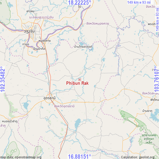
Phibun Rak GPS coordinates[2]
17° 33' 11.232" North, 103° 3' 28.584" East
| Map corner | latitude | longitude |
|---|---|---|
| Upper-left | 18.22225°, | 102.35482° |
| Center: | 17.55312°, | 103.05794° |
| Lower-right: | 16.88151°, | 103.76107° |
| Map W x H: | 149.1×149.1 km | = 92.6×92.6mi |
| max Lat: | 20.43353° ⇑15.6% North |
| Phibun Rak: | 17.55312° |
| min Lat: | ⇓84.4% South 5.77434° |
| min Long | Phibun Rak | max Long |
| 97.93288° | 103.05794° | 105.49506° |
| W 79.2%⇐ | ⇒20.8% E |
Elevation
Elevation of Phibun Rak is 182 m = 597 ft, and this is 56.5 m = 185 ft above average elevation for this country.
| Max E: |
1011 m = 3317 ft | 25.1% |
| Phibun Rak | 182 m 597 ft | |
| Avg. | 125.5 m = 412 ft | |
Min E: |
1 m = 3 ft | 74.9% |
See also: Thailand elevation on elevation.city.
Geographical zone
Phibun Rak is located in North Torrid zone (between Equator and Tropic of Cancer). Distance of this Northern Tropic circle is 654.2 km =406.5 mi to North.| Distance of | km | miles | from Phibun Rak |
|---|---|---|---|
| North Pole | 8055.3 | 5005.3 | to North |
| Arctic Circle | 5449.5 | 3386.2 | to North |
| Tropic Cancer | 654.2 | 406.5 | to North |
| Equator | 1951.7 | 1212.7 | to South |


Nearby cities:
15 places around Phibun Rak: (largest is in red/bold)
• Ban Dung
26.8 km =16.7 mi,  52°
52°
• Ban Na Muang
35.4 km =22 mi,  188°
188°
• Ban Nong Wua So
36.4 km =22.6 mi,  150°
150°
• Ban Phan Don
46.5 km =28.9 mi, 191°
• Chaiwan
34.3 km =21.3 mi, 147°
• Ku Kaeo
43.5 km =27 mi,  166°
166°
• Kumphawapi
49.6 km =30.8 mi, 185°
• Nong Han
22 km =13.7 mi, 166°
• Nong Khai
49.3 km =30.6 mi,  317°
317°
• Phen
22.6 km =14 mi,  314°
314°
• Sa Khrai
35.3 km =21.9 mi,  292°
292°
• Sang Khom
30.6 km =19 mi,  6°
6°
• Sawang Daen Din
43.2 km =26.8 mi,  101°
101°
• Thung Fon
23.3 km =14.5 mi,  112°
112°
• Udon Thani
32.6 km =20.3 mi,  242°
242°
Sources, notices
• [Note1] Compared only with cities in Thailand existing in our database
• [Src1] Map data: © OpenStreetMap contributors (CC-BY-SA)
• [Src2] Other city data from geonames.org with taken over terms of usage.
• [Src3] Geographical zone / Annual Mean Temperature by Robert A. Rohde @ Wikipedia
