Thung Si Udom geodata
Thung Si Udom (Changwat Ubon Ratchathani) is a seat of a second-order administrative division; located in Thailand in Asia/Bangkok (GMT+7) time zone. In our database, there are 331 cities with bigger population. Compared to other cities in Thailand, 54.9% of cities are located further ↑North; 98% of cities are located further ←West and 66.2% of cities have lower elevation than Thung Si Udom. Note1


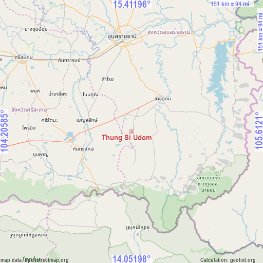
Thung Si Udom GPS coordinates[2]
14° 43' 58.908" North, 104° 54' 32.292" East
| Map corner | latitude | longitude |
|---|---|---|
| Upper-left | 15.41196°, | 104.20585° |
| Center: | 14.73303°, | 104.90897° |
| Lower-right: | 14.05198°, | 105.6121° |
| Map W x H: | 151.2×151.2 km | = 94×94mi |
| max Lat: | 20.43353° ⇑54.9% North |
| Thung Si Udom: | 14.73303° |
| min Lat: | ⇓45.1% South 5.77434° |
| min Long | Thung Si Udom | max Long |
| 97.93288° | 104.90897° | 105.49506° |
| W 98%⇐ | ⇒2% E |
Elevation
Elevation of Thung Si Udom is 162 m = 531 ft, and this is 36.5 m = 120 ft above average elevation for this country.
| Max E: |
1011 m = 3317 ft | 33.8% |
| Thung Si Udom | 162 m 531 ft | |
| Avg. | 125.5 m = 412 ft | |
Min E: |
1 m = 3 ft | 66.2% |
See also: Thailand elevation on elevation.city.
Geographical zone
Thung Si Udom is located in North Torrid zone (between Equator and Tropic of Cancer). Distance of this Northern Tropic circle is 967.8 km =601.4 mi to North.| Distance of | km | miles | from Thung Si Udom |
|---|---|---|---|
| North Pole | 8368.9 | 5200.2 | to North |
| Arctic Circle | 5763 | 3581 | to North |
| Tropic Cancer | 967.8 | 601.4 | to North |
| Equator | 1638.2 | 1017.9 | to South |


Nearby cities:
15 places around Thung Si Udom: (largest is in red/bold)
• Benchalak
26.6 km =16.5 mi,  285°
285°
• Buntharik
54.1 km =33.6 mi,  87°
87°
• Det Udom
26.5 km =16.5 mi,  43°
43°
• Kantharalak
29.7 km =18.5 mi,  249°
249°
• Kanthararom
54.7 km =34 mi,  318°
318°
• Khun Han
53.6 km =33.3 mi,  256°
256°
• Na Chaluai
43.2 km =26.8 mi,  123°
123°
• Na Yia
40.2 km =25 mi,  23°
23°
• Nam Khun
16.7 km =10.4 mi,  174°
174°
• Nam Kliang
47.7 km =29.6 mi,  296°
296°
• Non Kho
28.4 km =17.6 mi, 315°
• Samrong
33.4 km =20.8 mi,  336°
336°
• Si Rattana
47.8 km =29.7 mi,  278°
278°
• Siao
26.6 km =16.5 mi, 285°
• Warin Chamrap
51.4 km =31.9 mi,  354°
354°
Sources, notices
• [Note1] Compared only with cities in Thailand existing in our database
• [Src1] Map data: © OpenStreetMap contributors (CC-BY-SA)
• [Src2] Other city data from geonames.org with taken over terms of usage.
• [Src3] Geographical zone / Annual Mean Temperature by Robert A. Rohde @ Wikipedia
