Mae Taeng geodata
Mae Taeng (Chiang Mai) is a seat of a second-order administrative division; located in Thailand in Asia/Bangkok (GMT+7) time zone. In our database, there are 331 cities with bigger population. Compared to other cities in Thailand, 95.3% of cities are located further ↓South; 92.6% of cities are located further →East and 93.1% of cities have lower elevation than Mae Taeng. Note1


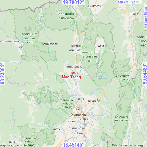
Mae Taeng GPS coordinates[2]
19° 7' 1.632" North, 98° 56' 30.336" East
| Map corner | latitude | longitude |
|---|---|---|
| Upper-left | 19.78012°, | 98.23864° |
| Center: | 19.11712°, | 98.94176° |
| Lower-right: | 18.45145°, | 99.64489° |
| Map W x H: | 147.7×147.7 km | = 91.8×91.8mi |
| max Lat: | 20.43353° ⇑4.7% North |
| Mae Taeng: | 19.11712° |
| min Lat: | ⇓95.3% South 5.77434° |
| min Long | Mae Taeng | max Long |
| 97.93288° | 98.94176° | 105.49506° |
| W 7.4%⇐ | ⇒92.6% E |
Elevation
Elevation of Mae Taeng is 336 m = 1102 ft, and this is 210.5 m = 691 ft above average elevation for this country.
| Max E: |
1011 m = 3317 ft | 6.9% |
| Mae Taeng | 336 m 1102 ft | |
| Avg. | 125.5 m = 412 ft | |
Min E: |
1 m = 3 ft | 93.1% |
See also: Thailand elevation on elevation.city.
Geographical zone
Mae Taeng is located in North Torrid zone (between Equator and Tropic of Cancer). Distance of this Northern Tropic circle is 480.3 km =298.4 mi to North.| Distance of | km | miles | from Mae Taeng |
|---|---|---|---|
| North Pole | 7881.4 | 4897.3 | to North |
| Arctic Circle | 5275.5 | 3278 | to North |
| Tropic Cancer | 480.3 | 298.4 | to North |
| Equator | 2125.6 | 1320.8 | to South |


Nearby cities:
15 places around Mae Taeng: (largest is in red/bold)
• Ban Thi
57 km =35.4 mi,  161°
161°
• Chiang Dao
27.7 km =17.2 mi,  4°
4°
• Chiang Mai
36.6 km =22.7 mi,  172°
172°
• Hang Dong
47.9 km =29.8 mi,  182°
182°
• Mae Hi
57.4 km =35.7 mi,  295°
295°
• Mae On
49.7 km =30.9 mi,  139°
139°
• Mae Wang
58.5 km =36.4 mi,  197°
197°
• Pai
59.3 km =36.8 mi, 297°
• Phrao
38.9 km =24.2 mi,  44°
44°
• Samoeng
37.1 km =23.1 mi,  216°
216°
• San Kamphaeng
45.4 km =28.2 mi, 155°
• San Pa Tong
54.6 km =33.9 mi,  185°
185°
• San Sai
31.8 km =19.8 mi, 160°
• Saraphi
45.9 km =28.5 mi, 167°
• Wiang Haeng
58.1 km =36.1 mi,  327°
327°
Sources, notices
• [Note1] Compared only with cities in Thailand existing in our database
• [Src1] Map data: © OpenStreetMap contributors (CC-BY-SA)
• [Src2] Other city data from geonames.org with taken over terms of usage.
• [Src3] Geographical zone / Annual Mean Temperature by Robert A. Rohde @ Wikipedia
