Pai geodata
Pai (Chiang Mai) is a populated place; located in Thailand in Asia/Bangkok (GMT+7) time zone. With population of 2,284 people, there are 320 cities with bigger population in this country. Compared to other cities in Thailand, 96.9% of cities are located further ↓South; 96.6% of cities are located further →East and 98.3% of cities have lower elevation than Pai. Note1


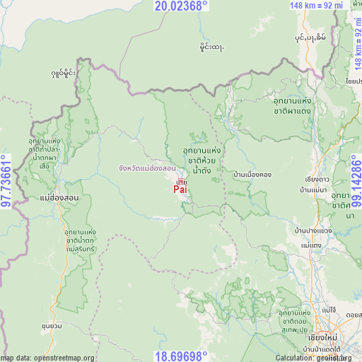
Pai GPS coordinates[2]
19° 21' 42.048" North, 98° 26' 23.028" East
| Map corner | latitude | longitude |
|---|---|---|
| Upper-left | 20.02368°, | 97.73661° |
| Center: | 19.36168°, | 98.43973° |
| Lower-right: | 18.69698°, | 99.14286° |
| Map W x H: | 147.5×147.5 km | = 91.7×91.7mi |
| max Lat: | 20.43353° ⇑3.1% North |
| Pai: | 19.36168° |
| min Lat: | ⇓96.9% South 5.77434° |
| min Long | Pai | max Long |
| 97.93288° | 98.43973° | 105.49506° |
| W 3.4%⇐ | ⇒96.6% E |
Elevation
Elevation of Pai is 510 m = 1673 ft, and this is 384.5 m = 1261 ft above average elevation for this country.
| Max E: |
1011 m = 3317 ft | 1.7% |
| Pai | 510 m 1673 ft | |
| Avg. | 125.5 m = 412 ft | |
Min E: |
1 m = 3 ft | 98.3% |
See also: Thailand elevation on elevation.city.
Geographical zone
Pai is located in North Torrid zone (between Equator and Tropic of Cancer). Distance of this Northern Tropic circle is 453.1 km =281.5 mi to North.| Distance of | km | miles | from Pai |
|---|---|---|---|
| North Pole | 7854.2 | 4880.4 | to North |
| Arctic Circle | 5248.4 | 3261.2 | to North |
| Tropic Cancer | 453.1 | 281.5 | to North |
| Equator | 2152.8 | 1337.7 | to South |


Nearby cities:
15 places around Pai: (largest is in red/bold)
• Chaem Luang
40 km =24.9 mi,  203°
203°
• Chai Prakan
84.1 km =52.3 mi,  60°
60°
• Chiang Dao
55.1 km =34.2 mi,  89°
89°
• Chiang Mai
85.5 km =53.1 mi,  137°
137°
• Khun Yuam
79.6 km =49.5 mi,  221°
221°
• Mae Hi
2.4 km =1.5 mi,  152°
152°
• Mae Hong Son
49.9 km =31 mi,  262°
262°
• Mae Taeng
59.3 km =36.8 mi,  117°
117°
• Mae Wang
90 km =55.9 mi,  157°
157°
• Phrao
79.9 km =49.6 mi, 89°
• Samoeng
64.9 km =40.3 mi, 151°
• San Sai
85.5 km =53.1 mi,  131°
131°
• Sop Pong
25.7 km =16 mi,  312°
312°
• Wiang Haeng
30.4 km =18.9 mi,  44°
44°
• Wiang Nuea
2.1 km =1.3 mi,  19°
19°
Sources, notices
• [Note1] Compared only with cities in Thailand existing in our database
• [Src1] Map data: © OpenStreetMap contributors (CC-BY-SA)
• [Src2] Other city data from geonames.org with taken over terms of usage.
• [Src3] Geographical zone / Annual Mean Temperature by Robert A. Rohde @ Wikipedia
