Mae Hi geodata
Mae Hi (Mae Hong Son) is a seat of a third-order administrative division; located in Thailand in Asia/Bangkok (GMT+7) time zone. In our database, there are 331 cities with bigger population. Compared to other cities in Thailand, 96.5% of cities are located further ↓South; 96.4% of cities are located further →East and 98.1% of cities have lower elevation than Mae Hi. Note1


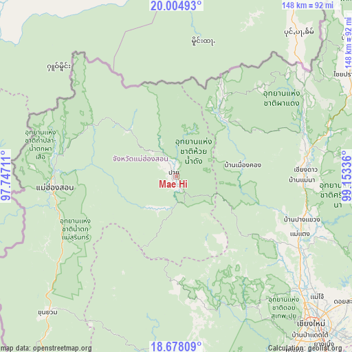
Mae Hi GPS coordinates[2]
19° 20' 34.296" North, 98° 27' 0.828" East
| Map corner | latitude | longitude |
|---|---|---|
| Upper-left | 20.00493°, | 97.74711° |
| Center: | 19.34286°, | 98.45023° |
| Lower-right: | 18.67809°, | 99.15336° |
| Map W x H: | 147.5×147.5 km | = 91.7×91.7mi |
| max Lat: | 20.43353° ⇑3.5% North |
| Mae Hi: | 19.34286° |
| min Lat: | ⇓96.5% South 5.77434° |
| min Long | Mae Hi | max Long |
| 97.93288° | 98.45023° | 105.49506° |
| W 3.6%⇐ | ⇒96.4% E |
Elevation
Elevation of Mae Hi is 504 m = 1654 ft, and this is 378.5 m = 1242 ft above average elevation for this country.
| Max E: |
1011 m = 3317 ft | 1.9% |
| Mae Hi | 504 m 1654 ft | |
| Avg. | 125.5 m = 412 ft | |
Min E: |
1 m = 3 ft | 98.1% |
See also: Thailand elevation on elevation.city.
Geographical zone
Mae Hi is located in North Torrid zone (between Equator and Tropic of Cancer). Distance of this Northern Tropic circle is 455.2 km =282.8 mi to North.| Distance of | km | miles | from Mae Hi |
|---|---|---|---|
| North Pole | 7856.3 | 4881.7 | to North |
| Arctic Circle | 5250.4 | 3262.4 | to North |
| Tropic Cancer | 455.2 | 282.8 | to North |
| Equator | 2150.7 | 1336.4 | to South |


Nearby cities:
15 places around Mae Hi: (largest is in red/bold)
• Chaem Luang
38.6 km =24 mi,  206°
206°
• Chai Prakan
84.2 km =52.3 mi,  59°
59°
• Chiang Dao
54 km =33.6 mi,  87°
87°
• Chiang Mai
83.2 km =51.7 mi,  137°
137°
• Khun Yuam
78.8 km =49 mi,  223°
223°
• Mae Hong Son
50.8 km =31.6 mi,  264°
264°
• Mae Taeng
57.4 km =35.7 mi,  115°
115°
• Mae Wang
87.6 km =54.4 mi,  157°
157°
• Pai
2.4 km =1.5 mi,  332°
332°
• Phrao
78.9 km =49 mi, 88°
• Samoeng
62.5 km =38.8 mi,  151°
151°
• San Sai
83.3 km =51.8 mi,  131°
131°
• Sop Pong
27.9 km =17.3 mi,  314°
314°
• Wiang Haeng
31.2 km =19.4 mi,  40°
40°
• Wiang Nuea
4.1 km =2.5 mi,  354°
354°
Sources, notices
• [Note1] Compared only with cities in Thailand existing in our database
• [Src1] Map data: © OpenStreetMap contributors (CC-BY-SA)
• [Src2] Other city data from geonames.org with taken over terms of usage.
• [Src3] Geographical zone / Annual Mean Temperature by Robert A. Rohde @ Wikipedia
