Mae On geodata
Mae On (Chiang Mai) is a seat of a second-order administrative division; located in Thailand in Asia/Bangkok (GMT+7) time zone. In our database, there are 331 cities with bigger population. Compared to other cities in Thailand, 94.3% of cities are located further ↓South; 88.3% of cities are located further →East and 95.6% of cities have lower elevation than Mae On. Note1


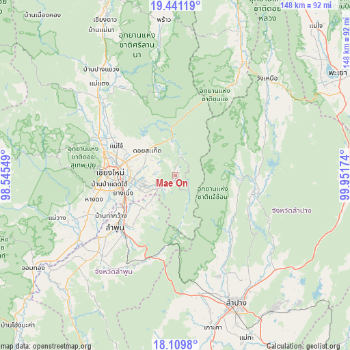
Mae On GPS coordinates[2]
18° 46' 36.516" North, 99° 14' 54.996" East
| Map corner | latitude | longitude |
|---|---|---|
| Upper-left | 19.44119°, | 98.54549° |
| Center: | 18.77681°, | 99.24861° |
| Lower-right: | 18.1098°, | 99.95174° |
| Map W x H: | 148×148 km | = 92×92mi |
| max Lat: | 20.43353° ⇑5.7% North |
| Mae On: | 18.77681° |
| min Lat: | ⇓94.3% South 5.77434° |
| min Long | Mae On | max Long |
| 97.93288° | 99.24861° | 105.49506° |
| W 11.7%⇐ | ⇒88.3% E |
Elevation
Elevation of Mae On is 401 m = 1316 ft, and this is 275.5 m = 904 ft above average elevation for this country.
| Max E: |
1011 m = 3317 ft | 4.4% |
| Mae On | 401 m 1316 ft | |
| Avg. | 125.5 m = 412 ft | |
Min E: |
1 m = 3 ft | 95.6% |
See also: Thailand elevation on elevation.city.
Geographical zone
Mae On is located in North Torrid zone (between Equator and Tropic of Cancer). Distance of this Northern Tropic circle is 518.1 km =321.9 mi to North.| Distance of | km | miles | from Mae On |
|---|---|---|---|
| North Pole | 7919.3 | 4920.8 | to North |
| Arctic Circle | 5313.4 | 3301.6 | to North |
| Tropic Cancer | 518.1 | 321.9 | to North |
| Equator | 2087.8 | 1297.3 | to South |


Nearby cities:
15 places around Mae On: (largest is in red/bold)
• Ban Thi
21.3 km =13.2 mi,  220°
220°
• Chae Hom
33.3 km =20.7 mi,  102°
102°
• Chiang Mai
27.8 km =17.3 mi,  273°
273°
• Hang Chat
50.9 km =31.6 mi,  168°
168°
• Hang Dong
36.1 km =22.4 mi,  253°
253°
• Lamphun
33.5 km =20.8 mi,  229°
229°
• Mae Taeng
49.7 km =30.9 mi,  319°
319°
• Mae Tha
36.5 km =22.7 mi,  198°
198°
• Mae Wang
53.2 km =33.1 mi, 250°
• Mueang Pan
26.7 km =16.6 mi,  92°
92°
• Pa Sang
42.9 km =26.7 mi, 229°
• San Kamphaeng
14 km =8.7 mi,  255°
255°
• San Pa Tong
40.7 km =25.3 mi, 246°
• San Sai
22.8 km =14.2 mi,  290°
290°
• Saraphi
23.5 km =14.6 mi, 252°
Sources, notices
• [Note1] Compared only with cities in Thailand existing in our database
• [Src1] Map data: © OpenStreetMap contributors (CC-BY-SA)
• [Src2] Other city data from geonames.org with taken over terms of usage.
• [Src3] Geographical zone / Annual Mean Temperature by Robert A. Rohde @ Wikipedia
