Tha Chana geodata
Tha Chana (Surat Thani) is a seat of a second-order administrative division; located in Thailand in Asia/Bangkok (GMT+7) time zone. In our database, there are 331 cities with bigger population. Compared to other cities in Thailand, 83.7% of cities are located further ↑North; 89.6% of cities are located further →East and 75.3% of cities have higher elevation than Tha Chana. Note1


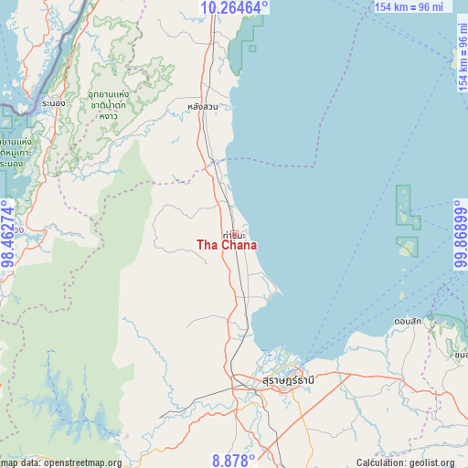
Tha Chana GPS coordinates[2]
9° 34' 19.308" North, 99° 9' 57.096" East
| Map corner | latitude | longitude |
|---|---|---|
| Upper-left | 10.26464°, | 98.46274° |
| Center: | 9.57203°, | 99.16586° |
| Lower-right: | 8.878°, | 99.86899° |
| Map W x H: | 154.2×154.2 km | = 95.8×95.8mi |
| max Lat: | 20.43353° ⇑83.7% North |
| Tha Chana: | 9.57203° |
| min Lat: | ⇓16.3% South 5.77434° |
| min Long | Tha Chana | max Long |
| 97.93288° | 99.16586° | 105.49506° |
| W 10.4%⇐ | ⇒89.6% E |
Elevation
Elevation of Tha Chana is 15 m = 49 ft, and this is 110.5 m = 363 ft below average elevation for this country.
| Max E: |
1011 m = 3317 ft | 75.3% |
| Avg. | 125.5 m = 412 ft | |
| Tha Chana | 15 m = 49 ft | |
Min E: |
1 m = 3 ft | 24.7% |
See also: Thailand elevation on elevation.city.
Geographical zone
Tha Chana is located in North Torrid zone (between Equator and Tropic of Cancer). Distance of Equator is 1064.3 km =661.3 mi to South.| Distance of | km | miles | from Tha Chana |
|---|---|---|---|
| North Pole | 8942.8 | 5556.8 | to North |
| Arctic Circle | 6336.9 | 3937.6 | to North |
| Tropic Cancer | 1541.6 | 957.9 | to North |
| Equator | 1064.3 | 661.3 | to South |


Nearby cities:
15 places around Tha Chana: (largest is in red/bold)
• Ban Nam Yuen
47.2 km =29.3 mi,  315°
315°
• Chaiya
21 km =13 mi,  170°
170°
• Don Sak
64.3 km =40 mi,  116°
116°
• Kanchanadit
56.1 km =34.9 mi,  143°
143°
• Kapoe
62.5 km =38.8 mi,  271°
271°
• Lamae
23.2 km =14.4 mi,  339°
339°
• Lang Suan
42.6 km =26.5 mi,  347°
347°
• Phato
49.1 km =30.5 mi,  299°
299°
• Ranong
72.8 km =45.2 mi,  306°
306°
• Surat Thani
51.4 km =31.9 mi,  159°
159°
• Takuk Nuea
42.4 km =26.3 mi,  209°
209°
• Tha Chang
34.4 km =21.4 mi,  175°
175°
• Tha Kham
51.8 km =32.2 mi, 171°
• Tha Khanon
64.6 km =40.1 mi,  201°
201°
• Thung Tako
60.5 km =37.6 mi, 351°
Sources, notices
• [Note1] Compared only with cities in Thailand existing in our database
• [Src1] Map data: © OpenStreetMap contributors (CC-BY-SA)
• [Src2] Other city data from geonames.org with taken over terms of usage.
• [Src3] Geographical zone / Annual Mean Temperature by Robert A. Rohde @ Wikipedia
