Ranong geodata
Ranong is a seat of a first-order administrative division; located in Thailand in Asia/Bangkok (GMT+7) time zone. With population of 24,561 people, there are 131 cities with bigger population in this country. Compared to other cities in Thailand, 82.9% of cities are located further ↑North; 95.3% of cities are located further →East and 62.2% of cities have higher elevation than Ranong. Note1


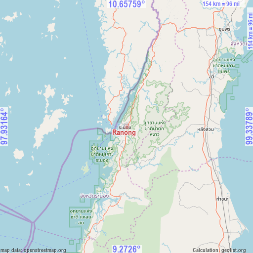
Ranong GPS coordinates[2]
9° 57' 56.988" North, 98° 38' 5.136" East
| Map corner | latitude | longitude |
|---|---|---|
| Upper-left | 10.65759°, | 97.93164° |
| Center: | 9.96583°, | 98.63476° |
| Lower-right: | 9.2726°, | 99.33789° |
| Map W x H: | 154×154 km | = 95.7×95.7mi |
| max Lat: | 20.43353° ⇑82.9% North |
| Ranong: | 9.96583° |
| min Lat: | ⇓17.1% South 5.77434° |
| min Long | Ranong | max Long |
| 97.93288° | 98.63476° | 105.49506° |
| W 4.7%⇐ | ⇒95.3% E |
Elevation
Elevation of Ranong is 38 m = 125 ft, and this is 87.5 m = 287 ft below average elevation for this country.
| Max E: |
1011 m = 3317 ft | 62.2% |
| Avg. | 125.5 m = 412 ft | |
| Ranong | 38 m = 125 ft | |
Min E: |
1 m = 3 ft | 37.8% |
See also: Thailand elevation on elevation.city.
Geographical zone
Ranong is located in North Torrid zone (between Equator and Tropic of Cancer). Distance of Equator is 1108.1 km =688.5 mi to South.| Distance of | km | miles | from Ranong |
|---|---|---|---|
| North Pole | 8899 | 5529.6 | to North |
| Arctic Circle | 6293.1 | 3910.3 | to North |
| Tropic Cancer | 1497.8 | 930.7 | to North |
| Equator | 1108.1 | 688.5 | to South |


Nearby cities:
15 places around Ranong: (largest is in red/bold)
• Ban Nam Yuen
27.2 km =16.9 mi,  111°
111°
• Chaiya
89.3 km =55.5 mi,  136°
136°
• Chumphon
83.8 km =52.1 mi,  45°
45°
• Kapoe
42.5 km =26.4 mi,  185°
185°
• Khura Buri
89.1 km =55.4 mi,  195°
195°
• Kra Buri
51 km =31.7 mi,  17°
17°
• La-Un
21 km =13 mi,  36°
36°
• Lamae
54.8 km =34.1 mi, 113°
• Lang Suan
48.6 km =30.2 mi,  92°
92°
• Phato
24.9 km =15.5 mi, 141°
• Sawi
60.1 km =37.3 mi,  59°
59°
• Suk Samran
72.7 km =45.2 mi, 198°
• Takuk Nuea
89.2 km =55.4 mi,  154°
154°
• Tha Chana
72.8 km =45.2 mi,  126°
126°
• Thung Tako
51.6 km =32.1 mi,  71°
71°
Sources, notices
• [Note1] Compared only with cities in Thailand existing in our database
• [Src1] Map data: © OpenStreetMap contributors (CC-BY-SA)
• [Src2] Other city data from geonames.org with taken over terms of usage.
• [Src3] Geographical zone / Annual Mean Temperature by Robert A. Rohde @ Wikipedia
