Lang Suan geodata
Lang Suan (Chumphon) is a seat of a second-order administrative division; located in Thailand in Asia/Bangkok (GMT+7) time zone. With population of 16,142 people, there are 200 cities with bigger population in this country. Compared to other cities in Thailand, 83% of cities are located further ↑North; 91.1% of cities are located further →East and 83.5% of cities have higher elevation than Lang Suan. Note1


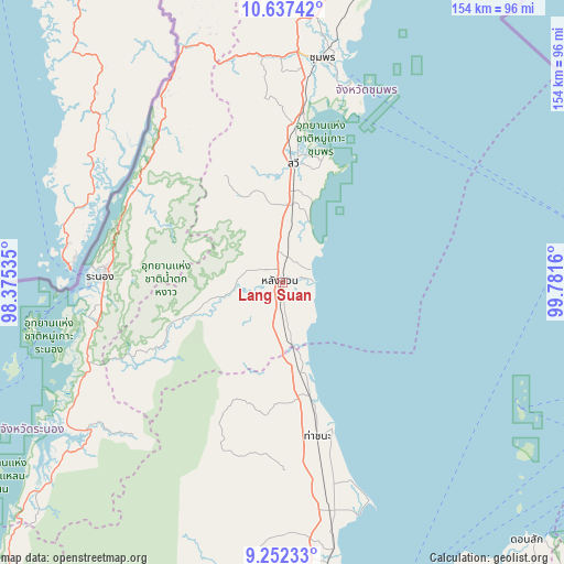
Lang Suan GPS coordinates[2]
9° 56' 44.196" North, 99° 4' 42.492" East
| Map corner | latitude | longitude |
|---|---|---|
| Upper-left | 10.63742°, | 98.37535° |
| Center: | 9.94561°, | 99.07847° |
| Lower-right: | 9.25233°, | 99.7816° |
| Map W x H: | 154×154 km | = 95.7×95.7mi |
| max Lat: | 20.43353° ⇑83% North |
| Lang Suan: | 9.94561° |
| min Lat: | ⇓17% South 5.77434° |
| min Long | Lang Suan | max Long |
| 97.93288° | 99.07847° | 105.49506° |
| W 8.9%⇐ | ⇒91.1% E |
Elevation
Elevation of Lang Suan is 11 m = 36 ft, and this is 114.5 m = 376 ft below average elevation for this country.
| Max E: |
1011 m = 3317 ft | 83.5% |
| Avg. | 125.5 m = 412 ft | |
| Lang Suan | 11 m = 36 ft | |
Min E: |
1 m = 3 ft | 16.5% |
See also: Thailand elevation on elevation.city.
Geographical zone
Lang Suan is located in North Torrid zone (between Equator and Tropic of Cancer). Distance of Equator is 1105.8 km =687.1 mi to South.| Distance of | km | miles | from Lang Suan |
|---|---|---|---|
| North Pole | 8901.2 | 5530.9 | to North |
| Arctic Circle | 6295.3 | 3911.7 | to North |
| Tropic Cancer | 1500.1 | 932.1 | to North |
| Equator | 1105.8 | 687.1 | to South |


Nearby cities:
15 places around Lang Suan: (largest is in red/bold)
• Ban Nam Yuen
24.5 km =15.2 mi,  251°
251°
• Chaiya
63.6 km =39.5 mi,  168°
168°
• Chumphon
62.2 km =38.6 mi,  10°
10°
• Kapoe
66.3 km =41.2 mi,  232°
232°
• Kra Buri
61 km =37.9 mi,  326°
326°
• La-Un
40.7 km =25.3 mi,  297°
297°
• Lamae
19.8 km =12.3 mi,  175°
175°
• Phato
37.3 km =23.2 mi,  242°
242°
• Ranong
48.6 km =30.2 mi,  272°
272°
• Sawi
32.5 km =20.2 mi, 5°
• Takuk Nuea
79.3 km =49.3 mi,  187°
187°
• Tha Chana
42.6 km =26.5 mi, 167°
• Tha Chang
76.8 km =47.7 mi, 170°
• Tha Sae
80.6 km =50.1 mi, 7°
• Thung Tako
18.3 km =11.4 mi,  1°
1°
Sources, notices
• [Note1] Compared only with cities in Thailand existing in our database
• [Src1] Map data: © OpenStreetMap contributors (CC-BY-SA)
• [Src2] Other city data from geonames.org with taken over terms of usage.
• [Src3] Geographical zone / Annual Mean Temperature by Robert A. Rohde @ Wikipedia
