Surat Thani geodata
Surat Thani is a seat of a first-order administrative division; located in Thailand in Asia/Bangkok (GMT+7) time zone. With population of 127,201 people, there are 13 cities with bigger population in this country. Compared to other cities in Thailand, 84.6% of cities are located further ↑North; 87.6% of cities are located further →East and 85.9% of cities have higher elevation than Surat Thani. Note1


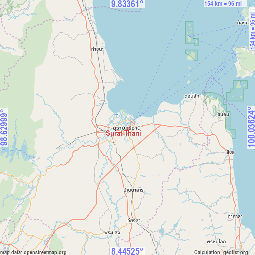
Surat Thani GPS coordinates[2]
9° 8' 24.396" North, 99° 19' 59.196" East
| Map corner | latitude | longitude |
|---|---|---|
| Upper-left | 9.83361°, | 98.62999° |
| Center: | 9.14011°, | 99.33311° |
| Lower-right: | 8.44525°, | 100.03624° |
| Map W x H: | 154.4×154.4 km | = 95.9×95.9mi |
| max Lat: | 20.43353° ⇑84.6% North |
| Surat Thani: | 9.14011° |
| min Lat: | ⇓15.4% South 5.77434° |
| min Long | Surat Thani | max Long |
| 97.93288° | 99.33311° | 105.49506° |
| W 12.4%⇐ | ⇒87.6% E |
Elevation
Elevation of Surat Thani is 10 m = 33 ft, and this is 115.5 m = 379 ft below average elevation for this country.
| Max E: |
1011 m = 3317 ft | 85.9% |
| Avg. | 125.5 m = 412 ft | |
| Surat Thani | 10 m = 33 ft | |
Min E: |
1 m = 3 ft | 14.1% |
See also: Surat Thani elevation on elevation.city.
Geographical zone
Surat Thani is located in North Torrid zone (between Equator and Tropic of Cancer). Distance of Equator is 1016.3 km =631.5 mi to South.| Distance of | km | miles | from Surat Thani |
|---|---|---|---|
| North Pole | 8990.8 | 5586.6 | to North |
| Arctic Circle | 6384.9 | 3967.4 | to North |
| Tropic Cancer | 1589.6 | 987.7 | to North |
| Equator | 1016.3 | 631.5 | to South |


Nearby cities:
15 places around Surat Thani: (largest is in red/bold)
• Ban Na Doem
28.6 km =17.8 mi,  185°
185°
• Ban Na San
37.9 km =23.5 mi,  174°
174°
• Ban Takhun
55.8 km =34.7 mi,  241°
241°
• Chaiya
31.1 km =19.3 mi,  331°
331°
• Don Sak
44 km =27.3 mi,  63°
63°
• Kanchanadit
15.3 km =9.5 mi,  79°
79°
• Khian Sa
36.2 km =22.5 mi,  204°
204°
• Nopphitam
65.2 km =40.5 mi,  135°
135°
• Phrasaeng
64.3 km =40 mi, 188°
• Takuk Nuea
40.4 km =25.1 mi,  285°
285°
• Tha Chana
51.4 km =31.9 mi,  339°
339°
• Tha Chang
20.7 km =12.9 mi,  311°
311°
• Tha Kham
11.6 km =7.2 mi,  253°
253°
• Tha Khanon
43.5 km =27 mi, 253°
• Wiang Sa
56.2 km =34.9 mi,  176°
176°
Sources, notices
• [Note1] Compared only with cities in Thailand existing in our database
• [Src1] Map data: © OpenStreetMap contributors (CC-BY-SA)
• [Src2] Other city data from geonames.org with taken over terms of usage.
• [Src3] Geographical zone / Annual Mean Temperature by Robert A. Rohde @ Wikipedia
