Chaiya geodata
Chaiya (Surat Thani) is a seat of a second-order administrative division; located in Thailand in Asia/Bangkok (GMT+7) time zone. With population of 12,223 people, there are 263 cities with bigger population in this country. Compared to other cities in Thailand, 83.9% of cities are located further ↑North; 89% of cities are located further →East and 83.5% of cities have higher elevation than Chaiya. Note1


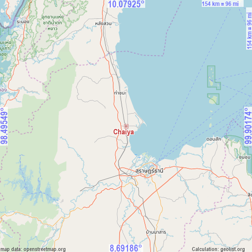
Chaiya GPS coordinates[2]
9° 23' 10.5" North, 99° 11' 54.996" East
| Map corner | latitude | longitude |
|---|---|---|
| Upper-left | 10.07925°, | 98.49549° |
| Center: | 9.38625°, | 99.19861° |
| Lower-right: | 8.69186°, | 99.90174° |
| Map W x H: | 154.3×154.3 km | = 95.9×95.9mi |
| max Lat: | 20.43353° ⇑83.9% North |
| Chaiya: | 9.38625° |
| min Lat: | ⇓16.1% South 5.77434° |
| min Long | Chaiya | max Long |
| 97.93288° | 99.19861° | 105.49506° |
| W 11%⇐ | ⇒89% E |
Elevation
Elevation of Chaiya is 11 m = 36 ft, and this is 114.5 m = 376 ft below average elevation for this country.
| Max E: |
1011 m = 3317 ft | 83.5% |
| Avg. | 125.5 m = 412 ft | |
| Chaiya | 11 m = 36 ft | |
Min E: |
1 m = 3 ft | 16.5% |
See also: Thailand elevation on elevation.city.
Geographical zone
Chaiya is located in North Torrid zone (between Equator and Tropic of Cancer). Distance of Equator is 1043.7 km =648.5 mi to South.| Distance of | km | miles | from Chaiya |
|---|---|---|---|
| North Pole | 8963.4 | 5569.6 | to North |
| Arctic Circle | 6357.5 | 3950.4 | to North |
| Tropic Cancer | 1562.3 | 970.8 | to North |
| Equator | 1043.7 | 648.5 | to South |


Nearby cities:
15 places around Chaiya: (largest is in red/bold)
• Ban Na Doem
57.2 km =35.5 mi,  167°
167°
• Ban Nam Yuen
65.6 km =40.8 mi,  326°
326°
• Ban Takhun
63.8 km =39.6 mi,  212°
212°
• Don Sak
54.7 km =34 mi,  98°
98°
• Kanchanadit
38.6 km =24 mi,  129°
129°
• Khian Sa
60.4 km =37.5 mi,  180°
180°
• Lamae
44 km =27.3 mi,  344°
344°
• Lang Suan
63.6 km =39.5 mi,  348°
348°
• Phato
64.5 km =40.1 mi,  314°
314°
• Surat Thani
31.1 km =19.3 mi,  151°
151°
• Takuk Nuea
29.2 km =18.1 mi,  235°
235°
• Tha Chana
21 km =13 mi, 350°
• Tha Chang
13.6 km =8.5 mi, 182°
• Tha Kham
30.9 km =19.2 mi, 173°
• Tha Khanon
47.9 km =29.8 mi, 214°
Sources, notices
• [Note1] Compared only with cities in Thailand existing in our database
• [Src1] Map data: © OpenStreetMap contributors (CC-BY-SA)
• [Src2] Other city data from geonames.org with taken over terms of usage.
• [Src3] Geographical zone / Annual Mean Temperature by Robert A. Rohde @ Wikipedia
