Chumphon geodata
Chumphon is a seat of a first-order administrative division; located in Thailand in Asia/Bangkok (GMT+7) time zone. With population of 55,835 people, there are 46 cities with bigger population in this country. Compared to other cities in Thailand, 82.3% of cities are located further ↑North; 89.4% of cities are located further →East and 91.2% of cities have higher elevation than Chumphon. Note1


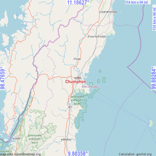
Chumphon GPS coordinates[2]
10° 29' 44.52" North, 99° 10' 46.956" East
| Map corner | latitude | longitude |
|---|---|---|
| Upper-left | 11.18627°, | 98.47659° |
| Center: | 10.4957°, | 99.17971° |
| Lower-right: | 9.80358°, | 99.88284° |
| Map W x H: | 153.7×153.7 km | = 95.5×95.5mi |
| max Lat: | 20.43353° ⇑82.3% North |
| Chumphon: | 10.4957° |
| min Lat: | ⇓17.7% South 5.77434° |
| min Long | Chumphon | max Long |
| 97.93288° | 99.17971° | 105.49506° |
| W 10.6%⇐ | ⇒89.4% E |
Elevation
Elevation of Chumphon is 8 m = 26 ft, and this is 117.5 m = 385 ft below average elevation for this country.
| Max E: |
1011 m = 3317 ft | 91.2% |
| Avg. | 125.5 m = 412 ft | |
| Chumphon | 8 m = 26 ft | |
Min E: |
1 m = 3 ft | 8.8% |
See also: Chumphon elevation on elevation.city.
Geographical zone
Chumphon is located in North Torrid zone (between Equator and Tropic of Cancer). Distance of Equator is 1167 km =725.1 mi to South.| Distance of | km | miles | from Chumphon |
|---|---|---|---|
| North Pole | 8840 | 5492.9 | to North |
| Arctic Circle | 6234.2 | 3873.8 | to North |
| Tropic Cancer | 1438.9 | 894.1 | to North |
| Equator | 1167 | 725.1 | to South |


Nearby cities:
15 places around Chumphon: (largest is in red/bold)
• Ban Nam Yuen
76.9 km =47.8 mi,  206°
206°
• Bang Saphan
87.6 km =54.4 mi,  24°
24°
• Bang Saphan Noi
70.5 km =43.8 mi, 23°
• Koh Tao
84.5 km =52.5 mi,  121°
121°
• Kra Buri
45.7 km =28.4 mi,  257°
257°
• La-Un
63.1 km =39.2 mi,  228°
228°
• Lamae
81.5 km =50.6 mi,  186°
186°
• Lang Suan
62.2 km =38.6 mi, 190°
• Pathio
28.1 km =17.5 mi,  32°
32°
• Phato
89.9 km =55.9 mi, 209°
• Ranong
83.8 km =52.1 mi, 225°
• Sawi
29.8 km =18.5 mi, 194°
• Tha Chana
102.7 km =63.8 mi,  180°
180°
• Tha Sae
18.8 km =11.7 mi,  357°
357°
• Thung Tako
44.1 km =27.4 mi, 193°
Sources, notices
• [Note1] Compared only with cities in Thailand existing in our database
• [Src1] Map data: © OpenStreetMap contributors (CC-BY-SA)
• [Src2] Other city data from geonames.org with taken over terms of usage.
• [Src3] Geographical zone / Annual Mean Temperature by Robert A. Rohde @ Wikipedia
