Phipun geodata
Phipun (Nakhon Si Thammarat) is a seat of a second-order administrative division; located in Thailand in Asia/Bangkok (GMT+7) time zone. In our database, there are 331 cities with bigger population. Compared to other cities in Thailand, 86.2% of cities are located further ↑North; 83.2% of cities are located further →East and 53.6% of cities have higher elevation than Phipun. Note1


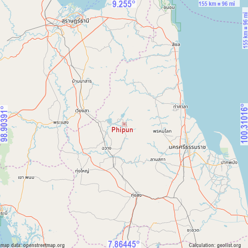
Phipun GPS coordinates[2]
8° 33' 37.296" North, 99° 36' 25.308" East
| Map corner | latitude | longitude |
|---|---|---|
| Upper-left | 9.255°, | 98.90391° |
| Center: | 8.56036°, | 99.60703° |
| Lower-right: | 7.86445°, | 100.31016° |
| Map W x H: | 154.6×154.6 km | = 96.1×96.1mi |
| max Lat: | 20.43353° ⇑86.2% North |
| Phipun: | 8.56036° |
| min Lat: | ⇓13.8% South 5.77434° |
| min Long | Phipun | max Long |
| 97.93288° | 99.60703° | 105.49506° |
| W 16.8%⇐ | ⇒83.2% E |
Elevation
Elevation of Phipun is 64 m = 210 ft, and this is 61.5 m = 202 ft below average elevation for this country.
| Max E: |
1011 m = 3317 ft | 53.6% |
| Avg. | 125.5 m = 412 ft | |
| Phipun | 64 m = 210 ft | |
Min E: |
1 m = 3 ft | 46.4% |
See also: Thailand elevation on elevation.city.
Geographical zone
Phipun is located in North Torrid zone (between Equator and Tropic of Cancer). Distance of Equator is 951.8 km =591.4 mi to South.| Distance of | km | miles | from Phipun |
|---|---|---|---|
| North Pole | 9055.2 | 5626.6 | to North |
| Arctic Circle | 6449.4 | 4007.5 | to North |
| Tropic Cancer | 1654.1 | 1027.8 | to North |
| Equator | 951.8 | 591.4 | to South |


Nearby cities:
15 places around Phipun: (largest is in red/bold)
• Ban Na San
37.8 km =23.5 mi,  314°
314°
• Chang Klang
21.6 km =13.4 mi,  193°
193°
• Chawang
18.7 km =11.6 mi,  217°
217°
• Lan Saka
30.3 km =18.8 mi,  133°
133°
• Na Bon
33.2 km =20.6 mi,  182°
182°
• Nakhon Si Thammarat
42 km =26.1 mi,  109°
109°
• Nopphitam
23.8 km =14.8 mi,  40°
40°
• Phra Phrom
40.6 km =25.2 mi, 127°
• Phrasaeng
39.5 km =24.5 mi,  271°
271°
• Phrom Khiri
24.1 km =15 mi,  99°
99°
• Tha Sala
37.5 km =23.3 mi,  71°
71°
• Tham Phannara
28 km =17.4 mi,  236°
236°
• Thung Song
44.7 km =27.8 mi,  169°
169°
• Thung Yai
39.1 km =24.3 mi, 222°
• Wiang Sa
27.7 km =17.2 mi,  287°
287°
Sources, notices
• [Note1] Compared only with cities in Thailand existing in our database
• [Src1] Map data: © OpenStreetMap contributors (CC-BY-SA)
• [Src2] Other city data from geonames.org with taken over terms of usage.
• [Src3] Geographical zone / Annual Mean Temperature by Robert A. Rohde @ Wikipedia
