Phrasaeng geodata
Phrasaeng (Surat Thani) is a seat of a second-order administrative division; located in Thailand in Asia/Bangkok (GMT+7) time zone. In our database, there are 331 cities with bigger population. Compared to other cities in Thailand, 86.1% of cities are located further ↑North; 88.4% of cities are located further →East and 72.3% of cities have higher elevation than Phrasaeng. Note1


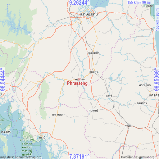
Phrasaeng GPS coordinates[2]
8° 34' 4.116" North, 99° 14' 51.216" East
| Map corner | latitude | longitude |
|---|---|---|
| Upper-left | 9.26244°, | 98.54444° |
| Center: | 8.56781°, | 99.24756° |
| Lower-right: | 7.87191°, | 99.95069° |
| Map W x H: | 154.6×154.6 km | = 96.1×96.1mi |
| max Lat: | 20.43353° ⇑86.1% North |
| Phrasaeng: | 8.56781° |
| min Lat: | ⇓13.9% South 5.77434° |
| min Long | Phrasaeng | max Long |
| 97.93288° | 99.24756° | 105.49506° |
| W 11.6%⇐ | ⇒88.4% E |
Elevation
Elevation of Phrasaeng is 19 m = 62 ft, and this is 106.5 m = 349 ft below average elevation for this country.
| Max E: |
1011 m = 3317 ft | 72.3% |
| Avg. | 125.5 m = 412 ft | |
| Phrasaeng | 19 m = 62 ft | |
Min E: |
1 m = 3 ft | 27.7% |
See also: Thailand elevation on elevation.city.
Geographical zone
Phrasaeng is located in North Torrid zone (between Equator and Tropic of Cancer). Distance of Equator is 952.7 km =592 mi to South.| Distance of | km | miles | from Phrasaeng |
|---|---|---|---|
| North Pole | 9054.4 | 5626.1 | to North |
| Arctic Circle | 6448.5 | 4006.9 | to North |
| Tropic Cancer | 1653.3 | 1027.3 | to North |
| Equator | 952.7 | 592 | to South |


Nearby cities:
15 places around Phrasaeng: (largest is in red/bold)
• Ban Na Doem
35.8 km =22.2 mi,  11°
11°
• Ban Na San
28.8 km =17.9 mi,  26°
26°
• Ban Takhun
54.6 km =33.9 mi,  313°
313°
• Chai Buri
22.2 km =13.8 mi,  238°
238°
• Chang Klang
41 km =25.5 mi,  122°
122°
• Chawang
32.4 km =20.1 mi, 119°
• Khao Phanom
40 km =24.9 mi,  212°
212°
• Khian Sa
31.1 km =19.3 mi,  350°
350°
• Lam Thap
55.3 km =34.4 mi,  174°
174°
• Na Bon
51.2 km =31.8 mi,  131°
131°
• Phipun
39.5 km =24.5 mi,  91°
91°
• Plai Phraya
42.4 km =26.3 mi,  264°
264°
• Tham Phannara
23.1 km =14.4 mi,  135°
135°
• Thung Yai
32.4 km =20.1 mi,  156°
156°
• Wiang Sa
15.1 km =9.4 mi,  59°
59°
Sources, notices
• [Note1] Compared only with cities in Thailand existing in our database
• [Src1] Map data: © OpenStreetMap contributors (CC-BY-SA)
• [Src2] Other city data from geonames.org with taken over terms of usage.
• [Src3] Geographical zone / Annual Mean Temperature by Robert A. Rohde @ Wikipedia
