Thung Song geodata
Thung Song (Nakhon Si Thammarat) is a seat of a second-order administrative division; located in Thailand in Asia/Bangkok (GMT+7) time zone. With population of 28,223 people, there are 116 cities with bigger population in this country. Compared to other cities in Thailand, 88.4% of cities are located further ↑North; 81.4% of cities are located further →East and 55.7% of cities have higher elevation than Thung Song. Note1


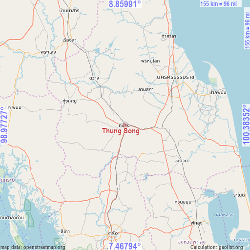
Thung Song GPS coordinates[2]
8° 9' 52.308" North, 99° 40' 49.404" East
| Map corner | latitude | longitude |
|---|---|---|
| Upper-left | 8.85991°, | 98.97727° |
| Center: | 8.16453°, | 99.68039° |
| Lower-right: | 7.46794°, | 100.38352° |
| Map W x H: | 154.8×154.8 km | = 96.2×96.2mi |
| max Lat: | 20.43353° ⇑88.4% North |
| Thung Song: | 8.16453° |
| min Lat: | ⇓11.6% South 5.77434° |
| min Long | Thung Song | max Long |
| 97.93288° | 99.68039° | 105.49506° |
| W 18.6%⇐ | ⇒81.4% E |
Elevation
Elevation of Thung Song is 57 m = 187 ft, and this is 68.5 m = 225 ft below average elevation for this country.
| Max E: |
1011 m = 3317 ft | 55.7% |
| Avg. | 125.5 m = 412 ft | |
| Thung Song | 57 m = 187 ft | |
Min E: |
1 m = 3 ft | 44.3% |
See also: Thailand elevation on elevation.city.
Geographical zone
Thung Song is located in North Torrid zone (between Equator and Tropic of Cancer). Distance of Equator is 907.8 km =564.1 mi to South.| Distance of | km | miles | from Thung Song |
|---|---|---|---|
| North Pole | 9099.3 | 5654 | to North |
| Arctic Circle | 6493.4 | 4034.8 | to North |
| Tropic Cancer | 1698.1 | 1055.2 | to North |
| Equator | 907.8 | 564.1 | to South |


Nearby cities:
15 places around Thung Song: (largest is in red/bold)
• Bang Khan
27.4 km =17 mi,  236°
236°
• Cha-uat
41.4 km =25.7 mi,  121°
121°
• Chaloem Phra Kiat
39.1 km =24.3 mi,  87°
87°
• Chang Klang
26.4 km =16.4 mi,  330°
330°
• Chawang
34.9 km =21.7 mi, 326°
• Chulabhorn
23 km =14.3 mi, 115°
• Huai Yot
42 km =26.1 mi,  186°
186°
• Lan Saka
26.8 km =16.7 mi,  30°
30°
• Na Bon
14.3 km =8.9 mi,  318°
318°
• Phra Phrom
31.1 km =19.3 mi,  51°
51°
• Phrom Khiri
42.9 km =26.7 mi,  21°
21°
• Ratsada
21.7 km =13.5 mi, 193°
• Ron Phibun
19.2 km =11.9 mi, 85°
• Tham Phannara
42.4 km =26.3 mi,  312°
312°
• Thung Yai
37.8 km =23.5 mi,  293°
293°
Sources, notices
• [Note1] Compared only with cities in Thailand existing in our database
• [Src1] Map data: © OpenStreetMap contributors (CC-BY-SA)
• [Src2] Other city data from geonames.org with taken over terms of usage.
• [Src3] Geographical zone / Annual Mean Temperature by Robert A. Rohde @ Wikipedia
