Ban Na San geodata
Ban Na San (Surat Thani) is a seat of a second-order administrative division; located in Thailand in Asia/Bangkok (GMT+7) time zone. With population of 21,900 people, there are 144 cities with bigger population in this country. Compared to other cities in Thailand, 85.5% of cities are located further ↑North; 87% of cities are located further →East and 61.8% of cities have higher elevation than Ban Na San. Note1


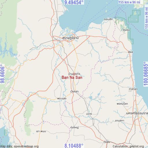
Ban Na San GPS coordinates[2]
8° 48' 1.296" North, 99° 21' 49.392" East
| Map corner | latitude | longitude |
|---|---|---|
| Upper-left | 9.49454°, | 98.6606° |
| Center: | 8.80036°, | 99.36372° |
| Lower-right: | 8.10488°, | 100.06685° |
| Map W x H: | 154.5×154.5 km | = 96×96mi |
| max Lat: | 20.43353° ⇑85.5% North |
| Ban Na San: | 8.80036° |
| min Lat: | ⇓14.5% South 5.77434° |
| min Long | Ban Na San | max Long |
| 97.93288° | 99.36372° | 105.49506° |
| W 13%⇐ | ⇒87% E |
Elevation
Elevation of Ban Na San is 40 m = 131 ft, and this is 85.5 m = 281 ft below average elevation for this country.
| Max E: |
1011 m = 3317 ft | 61.8% |
| Avg. | 125.5 m = 412 ft | |
| Ban Na San | 40 m = 131 ft | |
Min E: |
1 m = 3 ft | 38.2% |
See also: Thailand elevation on elevation.city.
Geographical zone
Ban Na San is located in North Torrid zone (between Equator and Tropic of Cancer). Distance of Equator is 978.5 km =608 mi to South.| Distance of | km | miles | from Ban Na San |
|---|---|---|---|
| North Pole | 9028.6 | 5610.1 | to North |
| Arctic Circle | 6422.7 | 3990.9 | to North |
| Tropic Cancer | 1627.4 | 1011.2 | to North |
| Equator | 978.5 | 608 | to South |


Nearby cities:
15 places around Ban Na San: (largest is in red/bold)
• Ban Na Doem
11 km =6.8 mi,  327°
327°
• Ban Takhun
53.9 km =33.5 mi,  282°
282°
• Chai Buri
49.1 km =30.5 mi,  220°
220°
• Chang Klang
52.5 km =32.6 mi,  155°
155°
• Chawang
44.4 km =27.6 mi, 159°
• Kanchanadit
42.3 km =26.3 mi,  16°
16°
• Khian Sa
18.8 km =11.7 mi, 284°
• Nopphitam
43.2 km =26.8 mi,  101°
101°
• Phipun
37.8 km =23.5 mi,  134°
134°
• Phrasaeng
28.8 km =17.9 mi,  206°
206°
• Surat Thani
37.9 km =23.5 mi,  354°
354°
• Tha Kham
37.4 km =23.2 mi,  337°
337°
• Tha Khanon
51.9 km =32.2 mi,  299°
299°
• Tham Phannara
42.4 km =26.3 mi,  175°
175°
• Wiang Sa
18.3 km =11.4 mi, 179°
Sources, notices
• [Note1] Compared only with cities in Thailand existing in our database
• [Src1] Map data: © OpenStreetMap contributors (CC-BY-SA)
• [Src2] Other city data from geonames.org with taken over terms of usage.
• [Src3] Geographical zone / Annual Mean Temperature by Robert A. Rohde @ Wikipedia
