Ko Lanta geodata
Ko Lanta (Krabi) is a populated place; located in Thailand in Asia/Bangkok (GMT+7) time zone. With population of 6,090 people, there are 304 cities with bigger population in this country. Compared to other cities in Thailand, 92.8% of cities are located further ↑North; 90.8% of cities are located further →East and 57.3% of cities have higher elevation than Ko Lanta. Note1


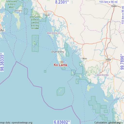
Ko Lanta GPS coordinates[2]
7° 32' 1.032" North, 99° 5' 11.292" East
| Map corner | latitude | longitude |
|---|---|---|
| Upper-left | 8.2301°, | 98.38335° |
| Center: | 7.53362°, | 99.08647° |
| Lower-right: | 6.83602°, | 99.7896° |
| Map W x H: | 155×155 km | = 96.3×96.3mi |
| max Lat: | 20.43353° ⇑92.8% North |
| Ko Lanta: | 7.53362° |
| min Lat: | ⇓7.2% South 5.77434° |
| min Long | Ko Lanta | max Long |
| 97.93288° | 99.08647° | 105.49506° |
| W 9.2%⇐ | ⇒90.8% E |
Elevation
Elevation of Ko Lanta is 51 m = 167 ft, and this is 74.5 m = 244 ft below average elevation for this country.
| Max E: |
1011 m = 3317 ft | 57.3% |
| Avg. | 125.5 m = 412 ft | |
| Ko Lanta | 51 m = 167 ft | |
Min E: |
1 m = 3 ft | 42.7% |
See also: Thailand elevation on elevation.city.
Geographical zone
Ko Lanta is located in North Torrid zone (between Equator and Tropic of Cancer). Distance of Equator is 837.7 km =520.5 mi to South.| Distance of | km | miles | from Ko Lanta |
|---|---|---|---|
| North Pole | 9169.4 | 5697.6 | to North |
| Arctic Circle | 6563.5 | 4078.4 | to North |
| Tropic Cancer | 1768.3 | 1098.8 | to North |
| Equator | 837.7 | 520.5 | to South |


Nearby cities:
15 places around Ko Lanta: (largest is in red/bold)
• Ban Ao Nang
64.6 km =40.1 mi,  331°
331°
• Hat Samran
63.1 km =39.2 mi,  121°
121°
• Huai Yot
66.8 km =41.5 mi,  64°
64°
• Kantang
49.4 km =30.7 mi,  106°
106°
• Khlong Thom
45.4 km =28.2 mi,  8°
8°
• Krabi
63 km =39.1 mi,  342°
342°
• Lam Thap
64 km =39.8 mi,  20°
20°
• Na Yong
67.1 km =41.7 mi,  87°
87°
• Nuea Khlong
60.6 km =37.7 mi,  350°
350°
• Phi Phi Don
41.6 km =25.8 mi,  303°
303°
• Saladan
10.4 km =6.5 mi, 328°
• Sikao
28.8 km =17.9 mi,  81°
81°
• Trang
57.9 km =36 mi, 87°
• Wang Wiset
41.1 km =25.5 mi, 56°
• Yan Ta Khao
66.1 km =41.1 mi,  104°
104°
Sources, notices
• [Note1] Compared only with cities in Thailand existing in our database
• [Src1] Map data: © OpenStreetMap contributors (CC-BY-SA)
• [Src2] Other city data from geonames.org with taken over terms of usage.
• [Src3] Geographical zone / Annual Mean Temperature by Robert A. Rohde @ Wikipedia
