Saladan geodata
Saladan (Krabi) is a populated place; located in Thailand in Asia/Bangkok (GMT+7) time zone. With population of 7,946 people, there are 294 cities with bigger population in this country. Compared to other cities in Thailand, 92.3% of cities are located further ↑North; 91.5% of cities are located further →East and 76.7% of cities have higher elevation than Saladan. Note1


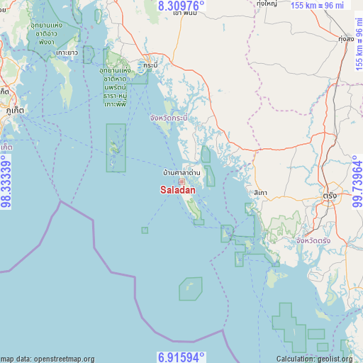
Saladan GPS coordinates[2]
7° 36' 48.312" North, 99° 2' 11.436" East
| Map corner | latitude | longitude |
|---|---|---|
| Upper-left | 8.30976°, | 98.33339° |
| Center: | 7.61342°, | 99.03651° |
| Lower-right: | 6.91594°, | 99.73964° |
| Map W x H: | 155×155 km | = 96.3×96.3mi |
| max Lat: | 20.43353° ⇑92.3% North |
| Saladan: | 7.61342° |
| min Lat: | ⇓7.7% South 5.77434° |
| min Long | Saladan | max Long |
| 97.93288° | 99.03651° | 105.49506° |
| W 8.5%⇐ | ⇒91.5% E |
Elevation
Elevation of Saladan is 14 m = 46 ft, and this is 111.5 m = 366 ft below average elevation for this country.
| Max E: |
1011 m = 3317 ft | 76.7% |
| Avg. | 125.5 m = 412 ft | |
| Saladan | 14 m = 46 ft | |
Min E: |
1 m = 3 ft | 23.3% |
See also: Thailand elevation on elevation.city.
Geographical zone
Saladan is located in North Torrid zone (between Equator and Tropic of Cancer). Distance of Equator is 846.5 km =526 mi to South.| Distance of | km | miles | from Saladan |
|---|---|---|---|
| North Pole | 9160.5 | 5692.1 | to North |
| Arctic Circle | 6554.6 | 4072.8 | to North |
| Tropic Cancer | 1759.4 | 1093.2 | to North |
| Equator | 846.5 | 526 | to South |


Nearby cities:
15 places around Saladan: (largest is in red/bold)
• Ban Ao Nang
54.1 km =33.6 mi,  332°
332°
• Ban Phru Nai
62.1 km =38.6 mi,  307°
307°
• Bang Khan
66.6 km =41.4 mi,  46°
46°
• Huai Yot
68.8 km =42.8 mi,  73°
73°
• Kantang
57.7 km =35.9 mi,  113°
113°
• Khao Phanom
72.5 km =45 mi,  1°
1°
• Khlong Thom
37.9 km =23.5 mi,  18°
18°
• Ko Lanta
10.4 km =6.5 mi,  148°
148°
• Krabi
52.9 km =32.9 mi,  344°
344°
• Lam Thap
58.3 km =36.2 mi,  28°
28°
• Nuea Khlong
51.1 km =31.8 mi,  355°
355°
• Phi Phi Don
32.4 km =20.1 mi,  295°
295°
• Sikao
34.3 km =21.3 mi,  97°
97°
• Trang
63.7 km =39.6 mi, 95°
• Wang Wiset
42.2 km =26.2 mi, 71°
Sources, notices
• [Note1] Compared only with cities in Thailand existing in our database
• [Src1] Map data: © OpenStreetMap contributors (CC-BY-SA)
• [Src2] Other city data from geonames.org with taken over terms of usage.
• [Src3] Geographical zone / Annual Mean Temperature by Robert A. Rohde @ Wikipedia
