Khlong Thom geodata
Khlong Thom (Krabi) is a seat of a second-order administrative division; located in Thailand in Asia/Bangkok (GMT+7) time zone. In our database, there are 331 cities with bigger population. Compared to other cities in Thailand, 89.9% of cities are located further ↑North; 89.7% of cities are located further →East and 83.5% of cities have higher elevation than Khlong Thom. Note1


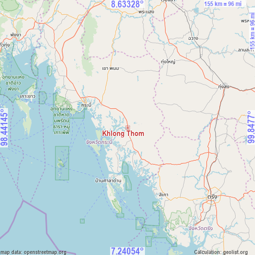
Khlong Thom GPS coordinates[2]
7° 56' 15" North, 99° 8' 40.452" East
| Map corner | latitude | longitude |
|---|---|---|
| Upper-left | 8.63328°, | 98.44145° |
| Center: | 7.9375°, | 99.14457° |
| Lower-right: | 7.24054°, | 99.8477° |
| Map W x H: | 154.9×154.9 km | = 96.3×96.3mi |
| max Lat: | 20.43353° ⇑89.9% North |
| Khlong Thom: | 7.9375° |
| min Lat: | ⇓10.1% South 5.77434° |
| min Long | Khlong Thom | max Long |
| 97.93288° | 99.14457° | 105.49506° |
| W 10.3%⇐ | ⇒89.7% E |
Elevation
Elevation of Khlong Thom is 11 m = 36 ft, and this is 114.5 m = 376 ft below average elevation for this country.
| Max E: |
1011 m = 3317 ft | 83.5% |
| Avg. | 125.5 m = 412 ft | |
| Khlong Thom | 11 m = 36 ft | |
Min E: |
1 m = 3 ft | 16.5% |
See also: Thailand elevation on elevation.city.
Geographical zone
Khlong Thom is located in North Torrid zone (between Equator and Tropic of Cancer). Distance of Equator is 882.6 km =548.4 mi to South.| Distance of | km | miles | from Khlong Thom |
|---|---|---|---|
| North Pole | 9124.5 | 5669.7 | to North |
| Arctic Circle | 6518.6 | 4050.5 | to North |
| Tropic Cancer | 1723.4 | 1070.9 | to North |
| Equator | 882.6 | 548.4 | to South |


Nearby cities:
15 places around Khlong Thom: (largest is in red/bold)
• Ban Ao Nang
38.7 km =24 mi,  288°
288°
• Bang Khan
37.6 km =23.4 mi,  74°
74°
• Chai Buri
58.8 km =36.5 mi,  352°
352°
• Huai Yot
56.4 km =35 mi,  106°
106°
• Khao Phanom
37.9 km =23.5 mi,  344°
344°
• Ko Lanta
45.4 km =28.2 mi,  188°
188°
• Krabi
29.8 km =18.5 mi,  300°
300°
• Lam Thap
22.1 km =13.7 mi,  47°
47°
• Nuea Khlong
21.9 km =13.6 mi,  312°
312°
• Phi Phi Don
46.5 km =28.9 mi,  241°
241°
• Ratsada
54 km =33.6 mi,  85°
85°
• Saladan
37.9 km =23.5 mi,  198°
198°
• Sikao
46.3 km =28.8 mi,  151°
151°
• Thung Yai
47.2 km =29.3 mi,  31°
31°
• Wang Wiset
35.8 km =22.2 mi,  128°
128°
Sources, notices
• [Note1] Compared only with cities in Thailand existing in our database
• [Src1] Map data: © OpenStreetMap contributors (CC-BY-SA)
• [Src2] Other city data from geonames.org with taken over terms of usage.
• [Src3] Geographical zone / Annual Mean Temperature by Robert A. Rohde @ Wikipedia
